THE DAIRI ZINC-LEAD PROJECT, NORTH SUMATRA, INDONESIA
Discovery to Feasibility
Terence W Middleton
Manager International Exploration, Herald Resources Ltd. 50 Colin St, West Perth WA 6005
Key words: sediment hosted massive sulphides; “Sedex” zinc-lead deposits; “MVT” zinc-lead deposits; Sumatran Fault System.
ABSTRACT
Sediment
hosted, massive sulphidic, zinc-lead mineralisation was first identified by
Herald Resources Ltd in the Sopokomil district of Dairi Regency, North Sumatra,
during preliminary reconnaissance and stream sediment sampling in late 1997,
prior to granting of a Generation VII Contract of Work. Staged exploration for stratiform, possibly
sedimentary exhalative (“sedex”) style mineralisation resulted in the tracing
over about 5km of strike on the NE flank of the complex Sopokomil Dome a series
of horizons and lenses, referred to as the “Julu Sedex Zone” (JSZ) in laminated
carbonaceous shale and dolomitic siltstones, of the designated Julu Member,.
Extensive, but lower grade
base metal and silver rich mineralisation in several styles, in particular the
designated “Jehe Mississippi Valley type”, has been discovered in the massive
dolostone footwall units which form the core of the Sopokomil Dome. The local
lithostratigraphic sequence is part of the poorly constrained
Permo-Carboniferous age Tapanuli Group, the basal rocks in this part of
Sumatra.
Exploration programs over
the past 5 years including stream sediment sampling, gridding, mapping, ground
and airborne EM surveys and diamond drilling of 20,953m in 87 holes, has
broadly traced the mineralisation around the dome. This culminated in the
selection of the Anjing Hitam deposit as subject of a Prefeasibility Study
conducted between July 2002 and June 2003.
The Anjing Hitam deposit
comprises a lower “Main Mineral Horizon” (MMH) and a discontinuous, thinner
“Upper Mineral Horizon”, about 10-20m higher, but affected by a hanging wall
shear zone and not considered for mining at this stage. The terrain has always
dictated that the deposit could only be extracted by underground mining and the
basis of the Prefeasibility Study was the mining and extraction at a rate of
1Mtpa.
The mining scheme designed
for the difficult 40-45° mining angle, and poor
hanging wall condition, proposes the extraction of 6.323Mt ore from the MMH at
a grade of 16.0% Zn, 9.9% Pb; processing in a conventional flotation
concentrator to produce separate lead and zinc concentrates and trucking to the
main port of the province for shipment to overseas smelters. The production of
745,100t net smelter payable zinc metal and 471,100t net smelter payable lead
metal is envisaged over the 6.6year mine life.
It seems likely that
further viable resources will be demonstrated in a number of prospects
elsewhere in the JSZ.
INTRODUCTION
The
Dairi Generation VII Contract of Work (CoW) was granted to PT Dairi Prima
Mineral (Herald Resources Ltd 80%, PT Aneka Tambang of Indonesia 20%) in
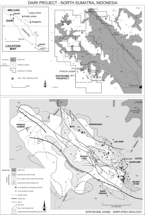
February, 1998. The CoW is largely in Dairi Regency, North Sumatra Province and
centred about 150km south of the provincial capital Medan.
It falls within the rugged,
rain forest clad, Barisan Ranges which rise to 1600m locally and being at 3°N latitude, experience wet tropical conditions with
3-4m annual rainfall. The wettest
months are September to April.
During the course of
preliminary reconnaissance for gold and base metals in late 1997, base metal
rich, apparently stratiform, massive sulphides were discovered in outcrop in
the creek-bed of Lae Sopokomil and were recognised as being at least of a
generic “Sedex” style (Lydon,1996, after Carne & Cathro 1982), hosted by
black shales and siltstones. This exciting, and somewhat unexpected, discovery
immediately focussed the exploration effort in this quarter, and, while varying
densities of exploration have been carried out throughout the CoW only minor
base metal occurrences have been discovered elsewhere.
Initial exploration at
Sopokomil in 1998 included stream sediment sampling, streamline mapping,
gridding and soil sampling, ground TEM survey and diamond drilling. Over the
following years, grid extension, mapping and sampling, successive ground EM
surveys, a CoW wide heliborne EM survey, DHEM surveys, detailed drilling at the designated Anjing Hitam
locality with a handful of holes in other sedex and carbonate hosted mineral
occurrences, metallurgical testwork etc led to the delineation of 10.0 Mt
indicated and inferred resources at Anjing Hitam. In 2002 a Prefeasibility
Study was commenced to determine the viability of an operation based on the
mining and processing of the Anjing Hitam deposit at a rate of 1Mtpa.
This study was completed in
June 2003 and lead to a Bankable Feasibility Study, which has just commenced
and is scheduled for completion by June 2004.
This virgin discovery is
ostensibly the first of its kind in Indonesia.
PREVIOUS EXPLORATION
Van
Bemmelen (1970) refers to an occurrence of lead-zinc-silver reported by Dutch
colonial officers at Bululaga (Figure 1) in the early 1900’s but only limited
production from wacke/carbonate hosted vein style mineralisation is apparent.
A regional 1:250,000
mapping survey was carried over much of northern Sumatra by the Geological
Research and Development Centre, Bandung in the late 1970’s, with aid and
technical assistance from the British Government’s Institute of Geological
Sciences and Overseas Development Administration. This led to the publication
of the Sidikalang 1:250,000 geological map sheet (in which the CoW falls) and
explanatory notes (Aldiss et al, 1983). This provides the geological background
to this paper. An associated broadly spaced stream sediment sampling survey
obtained high Pb-Zn values from a sample in lower Lae Sopokomil.
PT Aneka Tambang carried
out regional stream sediment surveys over a wide area in 1991 and 1993 which
also highlighted anomalous Pb-Zn in Lae Sopokomil (Simanjuntak, 1992). Limited follow-up work led to the discovery
of argentiferous galena-sphalerite bearing quartz veins at several localities
in the catchment. Base metal and weak gold anomalism was detected elsewhere in
the district and their Prospecting Authority area formed the basis of the Dairi
Joint Venture Contract of Work application.
Figure 1
Location, Regional Geology, Sopokomil Dome
Geology
EXPLORATION ACTIVITY
Geochemistry and Mapping
From the first recognition of “Sedex” style Zn-Pb mineralisation the Sopokomil district was given high priority status and detailed stream sediment sampling and streamline mapping commenced together with gridding and soil sampling. Stream sediment values to 62,100ppm Pb, 6,390Zn & 16ppm Ag have been obtained, detrital Pb oxide minerals giving rise to the high Pb values. Standard –80# silt sampling with flocculation and mixed acid digest/AAS analysis was used.
Soil sampling is nominal C-horizon or maximum ~1m depth with whole sample grinding and AAS analysis.
By far the strongest response in soils and silts is over the footwall Jehe carbonate member and streams draining it. Variable stockwork mineralised quartz veins, “MVT” mineralisation and supergene oxide deposit derived metals being fixed in the more alkaline soils are responsible. By comparison, soils over shale hosted sedex mineralisation give rise to generally only hundreds of ppm Zn & Pb and negligible Ag.
Ground Geophysics
In
1998 TEM using Zonge equipment was trialled over a small grid area. Good response was obtained over the sedex
mineralisation hosting JSZ.
In 1999 an expanded grid was subjected to a “UTEM” (University of Toronto EM) survey over the recognised eastern half of the Sopokomil Dome. This provided deeper penetration and interpretation of several anomalous foci around the Julu Sedex Zone have subsequently resulted in massive sulphide drillhole intercepts. A particularly strong anomaly – termed Dang Takkas, was detected on the south-western extremity of the dome. Three holes drilled to date have not resolved the anomaly source.and, while massive sulphides are yet to be intersected in the there, it is still not entirely resolved.
A heliborne EM survey of 1179 line km, using an Aerodat Eagle 5 frequency bird, and a simultaneous Scintrex CS2 magnetometer survey, was flown over most of the western part of the CoW. Conductive zones were delineated around the Sopokomil Dome (see Figure 1), complementing and extending the UTEM survey foci. A 14km NW-SE highly conductive trend, 20km north of Sopokomil was a major feature of the survey. Subsequent follow-up suggests that linear carbonaceous, pyritic shear zones in shales may be responsible.
Two down-hole EM surveys have been carried out. In 2001 a survey using Crone 4 component gear was successful in discriminating massive sulphide from conductive shale and pinpointing a deep, massive sulphide conductive zone at the Lae Jehe locality.
Drilling
Five
diamond drill programs have been completed over the past 5 years totalling
20,953m in 87 holes in. The first 2
were wide-spaced reconnaissance programs over the 3km trend of the JSZ on the
eastern flank of the Sopokomil Dome plus some holes into the footwall Jehe
carbonate hosted mineralisation. The
2000 and 2002 (Prefeasibility) programs concentrated on the delineation and
blocking out of the Anjing Hitam deposit to indicated resource status.
Metallurgy
Four
phases of flotation testwork have been carried out on Anjing Hitam
mineralisation, culminating with the 2002 Prefeasibility program which
indicated that fairly standard lead-zinc comminution practice, followed by flotation and regrind of concentrates, then
cleaner flotation can produce satisfactory grade concentrates at good
recovery. Results to date have
demonstrated 87% zinc recovery into a 56% Zn concentrate and 80% lead recovery
into a 64% concentrate.
PREFEASIBILITY STUDY
The
Prefeasibility Study was carried out between July 2002 – June 2003, and as well
as the drilling and metallurgical testwork programs mentioned above included
the following consultant programs:
1)
Resource Estimation
(in-house);
2)
Environmental Scoping
Study;
3)
Mining and Site
Geotechnical Studies;
4)
Mine Planning,
Scheduling and Costing Study
5)
Cemented Paste Backfill
Testwork;
6)
Concentrator and
Pasteplant Engineering and Costing Study;
7)
Transport/Logistics
Study;
8)
Smelter & Marketing;
9)
Financial Analysis.
The mining and processing
scheme proposed from the studies involves:
1)
Mining by a modified
drift and fill method, accessed by twin declines, at a rate of 1Mtpa ore with
closely coordinated cemented paste tailings backfill;
2)
Concentration by 2 stage
crushing, ball milling, rough flotation, concentrate regrind and cleaner
flotation to produce zinc and lead concentrates with most tailings returned to
stope backfill;
3)
Trucking concentrates
190km to the port of Belawan for shipment to overseas smelters.
The basic financial data
are:
1)
Total operating cash
costs USD0.30 per pound zinc equivalent;
2)
Gross payable metal
revenue USD 143.00/t ore
3)
Gross operating costs
pre-tax USD 106.89/t ore
4)
Gross operating surplus
USD 36.11/t ore
5)
Initial Capital Costs –
USD 83M or USD 13.12/t ore
6)
Total net cashflow
pre-tax – USD 145M
7)
Ungeared NPV @10%,
pre-tax – USD 61M.
GEOLOGY AND MINERALISATION
Regional Geology
The
basement rocks of northern Sumatra are the Permo-Carboniferous age Tapanuli
Group, generally sub-divided into the poorly constrained flysch dominated Kluet
Formation and the overlying (?) shelf carbonate Alas Formation (Aldis et al
1983). In the northern part of the CoW
this relationship is apparent while in the Sopokomil district it is not
possible to strictly assign the rocks to either and so the local term “Silima
Pungga Pungga Formation” is applied and this can be locally sub-divided into
several members, all carbonate bearing to a greater or lesser degree. They are relatively weakly metamorphosed but
often quite strongly tectonised.
The Tapanuli Group rocks
are affected by several deformation events – firstly in the Permian (op cit)
and one or more in the Mesozoic, with accompanying granite intrusion
(Cretaceous?), observable about 10km south of Sopokomil. The major deformation of the Tapanuli Group
occurred in the Neogene with the formation of the Barisan Geanticline (op cit)
and the Sumatran Fault System (SFS), which runs NW-SE along most of the length
of Sumatra. This has variable dextral
transcurrent to vertical movement. Most
fold axes in the Dairi region parallel this and SW vergence is apparent in the
Sopokomil Dome.
Adjacent to the SFS is the
Lake Toba caldera from which the cataclysmic eruption of ignimbritic Toba Tuff
occurred in the late Pleistocene, burying much of the rugged Barisan topography
and covering up to 20,000 km2 area (op cit). The NE catchments draining the Sopokomil
district are buried to ~650m ASL.
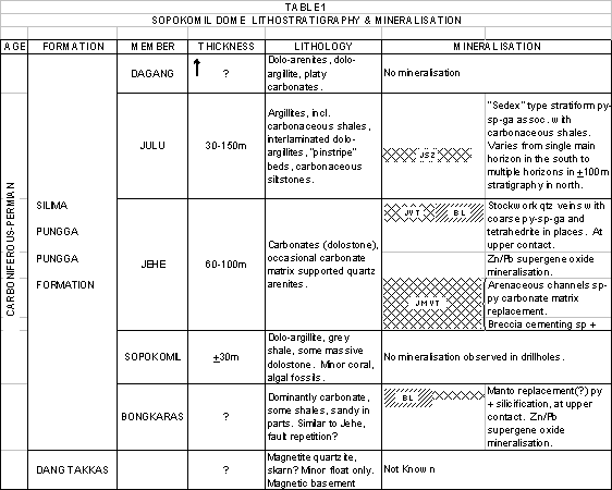
Lithostratigraphy
The
Sopokomil Dome exposed sequence of Tapanuli Group rocks comprises an upper,
monotonous dolo-argillite/arenite bedded sequence, termed the Dagang Member
(see Table 1). This is transitional
from the Julu Member – at the top “pinstripe” inter-laminated carbonaceous
shales and dolosiltstones and containing the “Julu Sedex Zone” series of
massive sulphide horizons, and in the lower part grading into bedded
carbonaceous, dolomitic siltstones, becoming progressively more dolomitised
There is a sharp contact
with a shelf carbonate sequence – collectively termed the Jehe Member, and
essentially massive, fine grained dolostone with no observed fossils but an
argillitic septum. The Sopokomil Member contains rare solitary corals and
possible algal growths. Erratic
carbonate matrixed quartz arenite facies intersected in drillholes may
represent sinuous channels.
On the SW flank of the
dome, and close to the near-surface manifestation of a strong magnetic
basement, is some float of a magnetite bearing quartzose lithology which may
conceivably be a skarn. This is termed
the Dang Takkas Formation but its relationship with the other rocks is not
clear.
Structure
The
Sopokomil Dome is about 4.5km long between the closure of the Julu Member
(Figure 1). It is aligned NW-SE, with
SW vergence and a sense of overturning.
It appears to be affected by an axis-parallel steep reverse fault system
which causes repetition of the Julu Member.
Dips on the NE flank (most
understood) range from 30-60°. There appear to have been three ductile
deformation events and a late brittle deformation (Marjoribanks, 1999).
Elsewhere in the CoW there
is a moderately open axial fold system trending NW-SE although most observed
dips are to the NE. The main strand of the Sumatran Fault System (Renun-Toro)
in this vicinity controls the course of the river Lae Renun while a WNW splay
controls Lae Simbelin.
Table 1
Sopokomil Dome – Lithostratigraphy and
Mineralisation
MINERAL DEPOSITS
Julu Sedex Zone
This
is traceable within the Julu Member from scattered outcrops in creek beds, soil
geochemical anomalism and geophysical surveys, together with a scattering of
drillholes around almost 5km of strike on the NE flank of the Sopokomil
Dome. The main heliborne EM conductive
zones are superimposed on geology in Figure 1.
The zone varies in character from a single thick horizon, termed the
Main Mineral Horizon (MMH), at Anjing Hitam in the far SE, to a thickness of up
to 100m with multiple, mostly thinner horizons in the NW. Facies variation appears responsible with
more quiescent local basinal conditions at Anjing Hitam while more carbonate-rich
detritus is present in the NW indicating more rapid deposition off the
dolostone shelf.
The mineralisation in the
sulphide horizons is commonly laminated, exhibits apparent graded bedding in
places, soft-sediment deformation of shale interlaminae etc, but has been
overprinted by possible successive early diagenetic stage mineral pulses and
several deformation events, including late hydrothermal and tectonic
modification. There is a pyrite rich
“proto-ore” type which is particularly fine grained, often well laminated and
comprising 50-60% pyrite, 20-30% sphalerite, 10-20% galena with minor
fragmental shale, quartz and barite. In
polished section, discrete pyrite anhedra in the 50m range are set in a sphalerite-galena intergrowing
matrix. There are commonly coarser
grained, remobilised, brecciated, recemented sphalerite-galena rich sections
with more shale fragments and only 5-10% pyrite. There are no other sulphide minerals in evidence.
Carbonate Hosted Mineralisation
Three main types occur in
the Jehe Carbonate member :
1)
Jehe Vein Type – a brittle fracture filling quartz vein system mostly restricted to the
upper 20m or so of the Jehe and not extending up into the Julu; contains coarse
sphalerite-galena-pyrite-tetrahedrite/tennantite, the latter quite silver-rich
with drill intercepts to 5m @ 2.5% Zn, 4.6% Pb, 92g/t Ag.
2)
Jehe Mississippi Valley Type –variably through the member with two styles – a
shrinkage/slumping breccia cementing sphalerite-carbonate +/- pyrite in up to
30m thick zones of >1% Zn, eg 28m @ 3.1% Zn, 0.02% Pb, 4g/t Ag; also a
matrix replacement style in carbonate matrixed quartz arenite with
sp>py>>ga and drill intercepts to 10m @ 7.5%Zn, 0.5% Pb, 10g/t Ag.
3)
Basuki Lode Type – occasional rubbly outcrop and creek exposures of brecciated,
ferruginised material with erratic high grade zinc oxide (smithsonite +
hemimorphite) and lead oxide (cerussite) mineralisation with drill intercepts
to 10m @ 6.3% Zn, 6.5% Pb, 149g/t Ag.
This type presumed to be recent karst deposited type from descending
metal rich solutions derived from weathering JSZ.
It is significant that
several lead isotope studies of the different JSZ massive sulphides versus Jehe
carbonate hosted types indicate that the “sedex” form a distinct population
(206Pb/204Pb<19.1 vs >19.1 for Jehe) which appears to be older than the
more radiogenic carbonate hosted sulphide types (McInnes, 2001).
Anjing Hitam Deposit
This
deposit at this stage appears to be fairly well constrained and comprises a
“Main Mineral Horizon” of about 750m strike length, aligned NW-SE, average 250m
dip extent, 12m average thickness, dipping 40-45°to the NE, shallowly plunging @ 15° to the SE, with a discontinuous “Upper Mineral
Horizon” 5-20m in the hanging wall. The
latter is affected by a bedding/layer parallel hanging wall shear.
MINERAL RESOURCES
Resource
estimation is based on a block model constructed from wireframing of
cross-sections. The blocks are mostly
25m x 5m x 2m thick. Grade and SG
interpolation has been carried out using inverse distance cubed using Surpac
software. A lower cut of 5% zinc
equivalent is used for the sedex mineralisation and no upper cut has been
applied. Exercises using nominal cutoff
have been applied to some of the sparsely drilled carbonate hosted zones. Current resources are tabulated below and
are considered compliant with JORC guidelines.
The “mining inventory” is
derived from the mining scheme applied to the Anjing Hitam measured and
indicated resource block model. It is 6.323Mt @ 16.0% Zn, 9.9% Pb or 21.5% Zn
equivalent.
Figure 2
Anjing Hitam
Plan and Cross-section 9900N
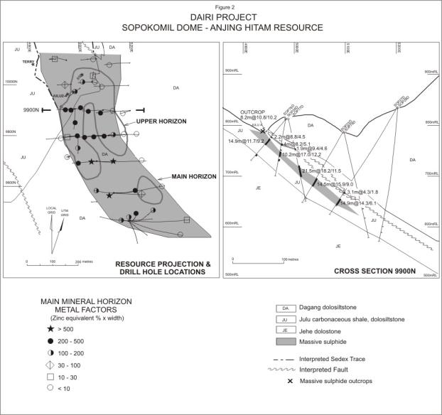
Table 2
Sopokomil
Resources
|
Zone |
Resource Category |
Tonnes (millions) |
Zinc (%) |
Lead (%) |
Zinc Equiv. (%) |
Silver (g/t) |
|
Anjing
Hitam JSZ |
Measured & Indicated |
7.1 |
16.6 |
10.2 |
22.4 |
13 |
|
Anjing
Hitam JSZ |
Inferred |
0.9 |
9.8 |
5.6 |
12.9 |
10 |
|
Basecamp
JSZ |
Inferred |
0.8 |
7.2 |
4.3 |
9.6 |
5 |
|
Lae
Jehe JSZ |
Inferred |
8.2 |
7.7 |
4.1 |
9.9 |
6 |
|
JMVT |
Inferred |
7.3 |
3.1 |
0.3 |
3.3 |
9 |
|
JVT |
Inferred |
0.9 |
1.0 |
1.7 |
2.3 |
75 |
ACKNOWLEDGEMENTS
Acknowledgement
is given to Dave Edwards, the original discoverer of the massive sulphide
outcrops, to Rob Seed, the original site senior geologist who carried out much
of the mapping and interpretation, his successor Ian Bruce and to Bernie
Kirkpatrick for successive resource estimations. Also to our hard working Indonesian geologists: Anton, Sapto,
Basuki and Herry and admin staff, especially Emmy and to Lorraine in Perth
office for patient and constructive “IT”.
Finally to the Board of Herald Resources Ltd for keeping the faith and
to Drs M Tumanggor, Bupati (Regent) of Dairi for ongoing encouragement.
REFERENCES
Aldis, D.T., Whandoyo, R., 1983, The Geology of the
Sidikalang Quadrangle, Sumatra.
Sjaefudian, A.G., KusjonoGeological Research & Development Centre, Indonesia.
Bemmelen, R.W. van, 1970, The Geology of Indonesia, 2nd
Edition. Martinus-Nijhoff, The Hague.
Lydon, J.W., 1995,
Sedimentary Exhalative Sulphides (Sedex); in Geology of Canadian Mineral
Deposit Types, Geology of Canada, Vol 8
Geological
Survey of Canada.
MacInnes, B.I.A., 2001, Dairi Pb Isotope Data.Unpublished Memo from CSIRO Exploration
& Mining to PT DPM.
Marjoribanks, R., 1999, An
Interpretation of the Geology and Mineralisation of the Sopokomil Zinc
Prospect. Unpublished report to PT DPM.
Simanjuntak, A.P., 1992, Report on Exploration of the Sopokomil District, Kecamatan Silima Pungga-Pungga, Kabupaten Dairi. Unpublished report by PT Aneka Tambang.
The Feedjit SMEDG Visitor Map
Which one of the red squares is you?