1 introduction
The state of
The sixth largest gold-producing region in
The focus of this project has been on three gold
deposits (Cohen’s Reef,
Cohen’s Reef, historically the most productive gold deposit in the Walhalla-Woods Point Goldfield, is a predominantly sediment-hosted, shear zone-associated, laminated to massive auriferous quartz vein system, in close proximity to a thin (< 1.7 metres) hornblende-diorite dyke. The reef was mined to a depth of over one kilometre, and produced 46 tonnes of gold (Ramsay and Willman 1988).
In contrast, the Tubal Cain and
The aim of our research is to understand, and eventually predict, favourable sites of gold mineralisation in the three different gold deposits, and throughout the goldfield, from drill hole data, structural mapping and historical adit map plans.
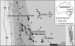 Figure 1. Geological map of the three gold deposits within
the Walhalla Goldfield (modified from Morand et al. 2006)
Figure 1. Geological map of the three gold deposits within
the Walhalla Goldfield (modified from Morand et al. 2006)
Thirty-eight samples from Cohen’s Reef, eleven
samples from
Preliminary results from petrological and geochemical analyses, including whole-rock and quantitative XRD, of the altered/ unaltered dyke and host metasediments from Cohen’s Reef, have reinforced results from hand sample and thin section studies. 3D mapping of the gold system from drillhole data and adit maps allowed the structural and lithological context of the alteration and mineralisation to be constrained.
2
Tectonic setting and
regional geology
The Walhalla-Woods Point Goldfield lies within the Late Devonian Walhalla Synclinorium, near the eastern margin of the Western Lachlan Orogen.
The Western Lachlan Orogen is one of three major thrust systems that formed due to plate convergence during the tectonic evolution of the Lachlan Orogen (450-340 Ma; Gray and Foster 2004). In regards to orogenic gold deposits, the Lachlan Orogen is comparable to other Phanerozoic orogens that formed by accretion of continental crust along the complex subduction zone of Gondwana (Gray and Foster 2004).
The Woods Point Dyke Swarm intruded the Walhalla Synclinorium along reverse faults and shear zones, commonly parallel to the strike of the fold axis, at 378-376 Ma (Bierlein et al. 2001) shortly before hydrothermal activity and gold mineralisation at 374-372 Ma (Bierlein et al. 2001). The dyke swarm forms a 150-kilometre long belt of N to NW-trending dykes, and is associated with over 30% of the known quartz-gold (“reef”) deposits in the field. Throughout the region, the dyke compositions vary from basic gabbros to hornblende diorites. The higher yielding dyke-hosted gold deposits within the Walhalla-Woods Point Goldfield, are hosted within west-dipping faults structures and/ or conjugate faults sets, such as Morning Star, A1 and Loch Fyne further to the north.
Three
phases of orogenic gold mineralisation are recognised in the Western Lachlan
Orogen. The first phase was closely associated with peak metamorphism at
440-455 Ma (Bierlein et al. 2001) and produced most of
the mesothermal, structurally controlled and economically important gold
deposits in the
3
characteristics of gold
deposits on the Walhalla goldfields
The three deposits were chosen due to the availability
of drill core and safe mine access. The deposits differ in regards to host
lithology – Cohen’s Reef is sediment-hosted but dyke-associated, whereas
3.1 Cohen’s Reef
The known extent of Cohen’s Reef (Fig. 1) is
approximately 1500 metres long and 1134 metres deep, along the valley of the
Cohen’s Reef is hosted within a steeply west-dipping reverse fault (Tomlinson et al. 1988). The reverse fault lies along the margin of an extensive but narrow dyke, within a complex fifty metre wide shear zone.
The shear zone is associated with tight steeply plunging asymmetric folds, suggesting strike-slip movement, prior to the emplacement of the dyke.
3.2
Eureka
The
Three reefs were historically worked with Goldstar Resources recently discovering four more auriferous reefs at depth. The parallel ladder reefs are hosted within high-angle reverse faults, which dip uncharacteristically to the east.
3.3 Tubal Cain
Tubal Cain (Fig. 1) is the largest known intrusion of the Woods Point Dyke Swarm.
Recent drilling has defined the shape of Tubal Cain of a length of 200 metres, a width of 180 metres and depth of 600 metres (Goldstar Resources, unpublished data). Eight reefs were historically worked with Goldstar Resources recently discovering seven more auriferous reefs at depth. The parallel ladder reefs dip to the southwest.
4 Preliminary Results
Based on geochemical drillhole traverses, petrological analyses, and 3D mapping of the gold deposit systems, a number of comparisons can be made.
Historical production along Cohen’s Reef concentrated on visible gold within the laminated reef system. Recent assay results have highlighted the increased levels of visible gold, and also the presence of disseminated gold, especially along dyke margins.
The ten highest gold assay results (5 – 12 ppm) from recent drilling in proximity to Cohen’s Reef are found in laminated veins within or on the margins of dyke; or in laminated or brecciated veins within meta-sedimentary rock, predominantly shale.
At Tubal Cain, elevated gold assay results are associated with laminated quartz veins, mineralised dyke with minor veins, and quartz breccia. Gold values greater than 10 ppm (15 – 211 ppm) are most commonly associated with the quartz breccia zones.
Highest gold assay results at
Based on observations from recent drillhole intersections,
laminated veins are more common in the sediment-hosted Cohen’s Reef, whereas
brecciated quartz veins are more common in the dyke-hosted deposits such as
Hydrothermal alteration, in particular the extent of the sulphide mineralisation, also varies between deposit and vein type. At Cohen’s Reef hydrothermal alteration is more extensive within the dyke. Visible carbonate bleaching varies from 4cm to over a 1 metre, depending on the width and concentration of the quartz veins. Visible sulphide alteration is localised to within a few centimetres of the mineralised vein, although elevated arsenic values can be detected up to 15 metres from the mineralised zone. Altered and bleached metasedimentary rocks exhibit an increase in SiO2 and CO2, and decrease in Al2O3, Fe2O3 and K2O. The highest gold and sulphur values are found within the dyke.
Arsenopyrite is commonly a good indicator for gold mineralisation, although at Cohen’s Reef elevated gold values do not correspond with presence of arsenopyrite. Instead, the elevated gold values (7 ppm) correspond with increased pyrite and arsenic (< 6000 ppb), therefore refractory gold may be found in the arsenic-rich pyrite rims.
Within the
Geochemical traverses along drill core from
5 conclusions
Based on current research, favourable sites for gold mineralisation in the Walhalla-Wood’s Point Goldfield are dyke-hosted quartz breccia zones.
The ten highest-yielding gold deposits within the Walhalla-Wood’s Point Goldfield are either dyke-hosted or dyke-associated/ sediment hosted.
A number of hydrothermal phases are evident in all three deposits, from initial barren quartz or carbonate veins, to quartz-carbonate veins associated with sulphides, to later gold-rich quartz veins. The initial phases of hydrothermal activity formed the crack-seal laminated quartz-carbonate veins with minor sulphide and host rock selvages. The later hydrothermal events occurred at shallower levels under more brittle conditions, and are characterized by open space vein fill with vugs, brecciated quartz zones, and the highest gold values.
The extent of hydrothermal alteration in wallrock is an exploration tool best suited to gold associated with laminated veins. Sulphide mineralisation associated with breccia zones is more localised, and not necessarily indicative of gold values.
ACKNOWLEDGEMENTS
ARC Linkage funding, along with direct and in-kind support from collaborative
partners Geoscience Victoria and Goldstar Resources supported this research.
Stafford McKnight is thanked for assistance in
REFERENCES
Bierlein FP, Hughes M, Dunphy J,
McKnight S, Reynold P, Waldron H (2001) Tectonic and economic implications of
trace element, 40Ar/39Ar and Sm-Nd data from mafic dykes associated with
orogenic gold mineralisation in central
Bierlein
FP, Maher S (2001) Orogenic disseminated gold in Phanerozoic fold belts — examples
from
Morand VJ, Wilman CE, Taylor DH, Quinn C, Vandenberg AHM, Seymon AR, Hough M (2006) Walhalla and parts of Seaton and
Moe 1:50 000 geological map. GeoScience
Ramsay WRH, Bierlein FP,
Arne DC, VandenBerg AHM (1998) Turbidite-hosted gold deposits of
central Victoria, Australia; their regional setting, mineralising styles, and
some genetic constraints.
Ramsey WRH, Willman CE (1988) Economic Geology. In:
Tomlinson KM, Wilson CJL, Hazeldene R, Lohe EM (1988) Structural control on gold mineralisation at Walhalla, Victoria. Australian Journal of Earth Sciences 35: 421-444
VandenBerg AHM, Cayley RA, Willman
CE et al. (2006) Walhalla – Woods Point – Tallangallook special map area geological
report. Geological Survey of Victoria Report 127: pp455