THE FERNDALE COPPER-GOLD PROJECT – A CASE STUDY ON EXPLORING FOR ORDOVICIAN PORPHYRY SYSTEMS BENEATH TERTIARY COVER
Damon Bird
Hargraves Resources NL, Locked
Bag 7, Blayney, NSW, 2799
INTRODUCTION
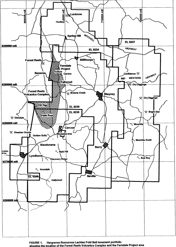
The Ferndale Project covers an area of approximately 7 square kilometres and is centred 4.5 kilometres to the southeast of the hamlet of Forest Reefs, in central western New South Wales (Figure 1). The project area covers part of the eastern margin of the Forest Reefs Volcanics - a package of mafic-intermediate volcaniclastic and comagmatic potassic intrusive rocks that are interpreted to represent the core of a Late Ordovician to Early Silurian magmatic centre. From an economic perspective, the Forest Reefs Volcanics are considered the most significant lithological association in the Orange district, as they are host to a number of significant porphyry-related gold and/or copper mineralised systems, including the Cadia/Ridgeway system of Newcrest Mining Ltd.
With the refocusing of Hargraves’ exploration efforts to the Forest Reefs Volcanics in July 1998, a grass-roots exploration programme involving detailed geological mapping, ground magnetic surveying, rock-chip and soil sampling was initiated in the Ferndale Project area. The objective of this programme was to evaluate the potential for intrusive-related and/or structurally controlled precious metal mineralisation, near the northern margin of the Ordovician Tallwood Monzonite. As the northern contact of the Tallwood Monzonite with the Forest Reefs Volcanics was thought to be obscured by Tertiary basalt, the project area had been subjected to very limited historical exploration.
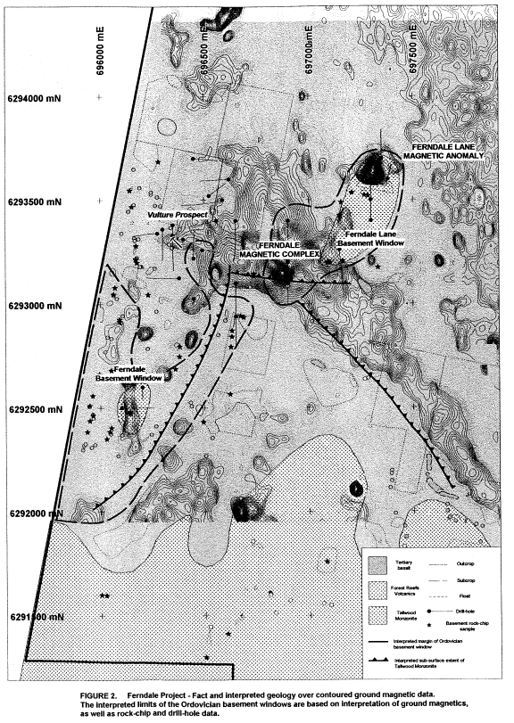
Initial ground work revealed the likely existence of two windows of altered Ordovician basement, in areas where extensive float trains and sporadic outcrops of Tertiary basalt dominate. The most significant of these – the Ferndale basement window – occurs at the intersection of several major structural trends and is partially coincident with a prominent magnetic “high” complex (Ferndale Magnetic Complex).
Reconnaissance drill testing was subsequently undertaken to provide geological information over the Ferndale Magnetic Complex and Ordovician basement windows. The drilling programme identified hydrothermal alteration and a metal zonation pattern characteristic of many southwest Pacific porphyry copper-gold systems. The programme culminated with the identification of skarn-hosted gold-copper-molybdenum mineralisation beneath Tertiary basalt cover in the western part of the project area (Vulture Prospect). Analysis of the relationship between hydrothermal alteration, metal zonation patterns and structure indicates that gold and copper mineralisation is linked to a proximal intrusive source.
Further exploration work is underway to test the significant potential for porphyry copper-gold mineralisation within the Ferndale Project area.
PREVIOUS EXPLORATION
CURRENT
EXPLORATION
Geological
Mapping and Rock-chip Sampling
Detailed (1:4,000 scale) geological mapping, supported by rock-chip sampling and petrological analyses, was undertaken across the project area. A total of 58 float samples of strongly altered volcaniclastic and intrusive rocks were collected from areas previously thought to be covered by deep Tertiary basalt. The majority of samples were hydrothermally altered to quartz-tourmaline, quartz-epidote or strongly oxidised (once sulphide mineralised) ferruginous material and provided the key evidence for the existence of two barely exposed windows of Ordovician basement geology (Figure 2). The presence of quartz-tourmaline vein material was considered particularly encouraging, as this type of alteration is spatially associated with a number porphyry-related copper-gold systems within the Forest Reefs Volcanics to the west (e.g. Cadia East (Minfo, 1997)).
Rock-chip samples were assayed for Au, Cu, Pb, Zn, Ag, As, Bi and Mo. Assay results failed to highlight any significant anomalism (ie. maximum values of 0.12g/t Au and 525ppm Cu), but were not considered discouraging for the geological environment in question.
Soil
Sampling
A -80# B-horizon soil sampling programme was subsequently undertaken to test the extent of Ordovician basement exposure. A total of 345 samples were collected and analysed for Au, Cu, Pb, Zn, Ag, As, Bi, Mo, Te, Sb and Hg.
Elevated Pb, Zn, As and (?)Mo results highlighted the western edge of the project area, however it was not known whether these values were truly anomalous or just indicative of the extent of the basement window. For this reason, soil assay results were interpreted with caution until a more widespread understanding of the relationship between geochemistry and geology was determined from outcropping areas of the Forest Reefs Volcanics to the south.
Ground
Magnetic Survey
A 190 line-kilometre ground magnetic survey was completed to provide high-resolution data over the northern part of the project area not previously covered by the Hargraves’ heliborne magnetic survey (White, 1999a). The survey was conducted along 50 metre spaced, east-west oriented lines with readings taken at 5 metre intervals. The survey was also extended to the east over the interpreted contact between the Forest Reefs Volcanics and Blayney Volcanics.
Ground magnetics clearly defined the Ferndale Magnetic Complex - a northwest trending magnetic “high” complex that is coincident with the northern margin of the Tallwood Monzonite and entirely obscured by Tertiary basalt. Several prominent magnetic “lows” occur along the southern edge of the Ferndale Magnetic Complex and were interpreted as alteration zones linked possibly to a later intrusive event. Higher resolution data was also established for a prominent magnetic “high” anomaly located to the north of Ferndale Lane. The anomaly appears on regional magnetic data and is sourced by an outcropping magnetite-bearing monzodiorite and contact metamorphosed pyrrhotite-bearing volcaniclastics.
Reverse
Circulation Percussion/Diamond Drilling Programme
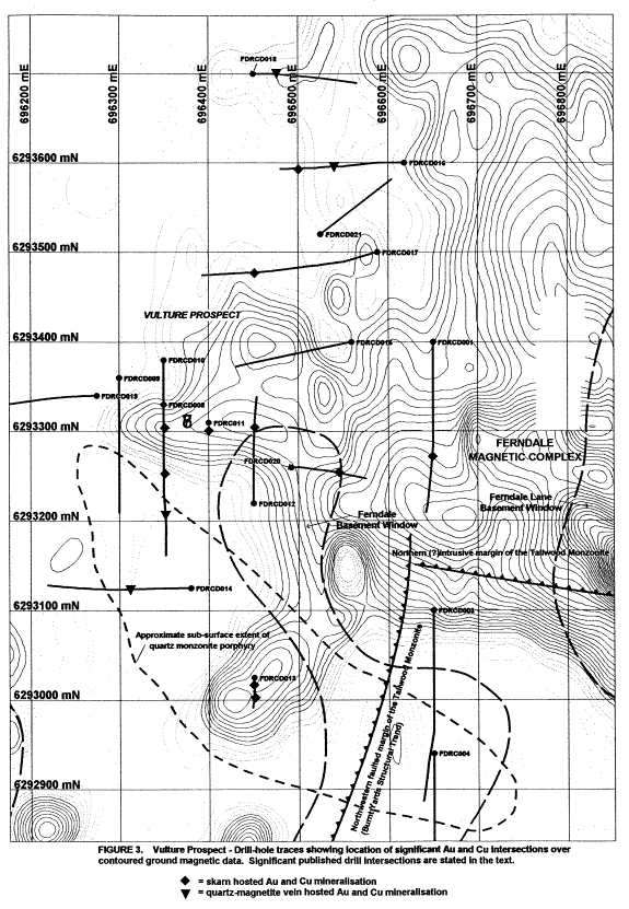
A reverse circulation percussion/diamond-drilling programme was initiated during January 1999 to obtain critical geological and structural information across the Ferndale Magnetic Complex and from the Ordovician basement windows. The drilling programme proved a major success with the identification of porphyry-related gold and copper mineralisation on the western side of the Ferndale Magnetic Complex (Figure 3). Mineralisation at the Vulture Prospect is hosted entirely within the Forest Reefs Volcanics, with the highest-grade intersections occurring within a 30-metre thick flat-lying skarn zone (Bird, 1999a). Gold and copper mineralisation varies in width and intensity within the skarn and is typically associated with elevated molybdenum (max. 3130ppm) geochemistry. The best results from drilling are summarised below:
Hole FDRCD008 13.5m @ 0.43g/t Au and 1.06% Cu from 141m
Hole FDRCD010 27m @ 0.39g/t Au and 0.78% Cu from 126m
Hole FDRC011 31m @ 0.25g/t Au and 0.4% Cu from 97m
Hole FDRCD012 16m @ 0.95g/t Au and 0.6% Cu from 132m
Gold and copper mineralisation has also been identified in association with sheeted quartz-magnetite ± pyrite ± chalcopyrite vein systems, 200 metres to the north and south of the Vulture skarn mineralisation (Bird, 1999b). The quartz vein systems are clearly porphyry related and occur within a major northeast trending structural corridor. They are interpreted to be part of the same hydrothermal system responsible for copper and gold mineralisation in the skarn. The best vein intersections were:
Hole FDRCD016 11m @ 1.38g/t Au and 0.27% Cu from 152m
(incl. 6m @ 2.10g/t Au and 0.44% Cu from 157m)
Hole FDRCD014 11m @ 0.17g/t Au and 0.13% Cu from 129m
23m @ 0.17g/t Au and 0.23% Cu from 170m
19m @ 0.32g/t Au and 0.22% Cu from 201m
The drilling programme also provided valuable geological information regarding:
· the nature of the northern contact of the Tallwood Monzonite with the Forest Reefs Volcanics
· the existence of a large porphyritic quartz monzonite intrusion along the northern margin of the Tallwood Monzonite. This intrusive is not known to crop out at surface
· the existence of a hydrothermal breccia zone located near the northern margin of the Tallwood Monzonite
· alteration and metal zonation patterns across the Ferndale Magnetic Complex
Induced
Polarisation Survey
An orientation 100-metre dipole
IP survey was undertaken over the Vulture skarn during April 1999 to determine
if the copper-gold mineralisation could be detected by remote means. The orientation survey highlighted two areas
of anomalous chargeability, coincident with areas of known skarn alteration and
mineralisation. These anomalies were
modeled, and found to be diagnostic of a flat-lying chargeable zone at similar
depth and with similar thickness to the skarn zones intersected by drilling
(White, 1999b).
A more extensive 100-metre
dipole IP survey was then undertaken over the entire project area. Traverse lines were spaced at approximately
200 metres and oriented in a NNW-SSE direction to minimise fence effects. The IP survey defined a major zone of
chargeability that extends for over 400 metres to the north of the Vulture
skarn zone. This zone was detected on several traverses and has a similar
signature to chargeability anomalies generated by the flat-lying skarn
zone. Follow-up drilling is currently
underway and has confirmed the continuation of the skarn for over 300 metres to
the north of previous drilling.
GEOLOGY
Tertiary Basalt
A Tertiary veneer of locally vesicular olivine basalt
dominates the surface geology of the Ferndale Project area and masks the
northern contact of the Tallwood Monzonite with the Forest Reefs
Volcanics. The basalt occurs as rare
outcrops, sporadic subcrops and extensive float trains and is most widespread
in the northern and central parts of the area.
Recent drilling at the Vulture prospect revealed that the basalt varies
in depth from a few metres to in excess of 40 metres, over a 150 metre horizontal
distance.
Forest
Reefs Volcanics
The Forest Reefs Volcanics in the Ferndale Project are comprised of an interbedded sequence of volcanic arenites, siltstones, polymict volcaniclastics and minor pyroxene-phyric lava units. The volcanic stratigraphy is relatively flat lying across the project area and at the Vulture Prospect dips at around 10-15° to the north.
Calc-silicate
(skarn) horizons have been intersected in drilling at the Vulture Prospect and
to the north of Ferndale Lane. These
occur at the contact between a thinly interbedded sequence of volcanic arenites
and siltstones and an underlying matrix supported polymict volcaniclastic. The skarns vary in thickness from several
metres to in excess of 30m and represent the product of metasomatic replacement
of a sparsely fragmental, limy volcanic siltstone unit. At the Vulture Prospect, the skarns are of
economic interest as they host locally significant, porphyry-related
gold-copper-molybdenum mineralisation.
Tallwood
Monzonite
In the Ferndale Project area, the Forest Reefs Volcanics have been intruded by at least two monzonitic intrusions. The largest of these is the Ordovician Tallwood Monzonite – a coarse-grained, magnetite-bearing hornblende-biotite monzonite. The broadly east-west trending northern margin of the Tallwood Monzonite is obscured by Tertiary basalt, with subcrop and float train exposure limited to the southern part of the project area. Ground magnetic data suggests the northern margin of the monzonite is an intrusive contact that dips moderately to steeply to the north and has been disrupted by minor post-emplacement faulting. In contrast, the north-western contact of the monzonite with the Forest Reefs Volcanics has been subjected to significant post-emplacement faulting along a major northeast trending structural corridor (Burnt Yards structural trend). Copper and gold mineralisation at the Vulture Prospect post-dates and is unrelated to the Tallwood Monzonite.
Quartz
Monzonite Porphyry
Drilling along the southern flank of the Ferndale Magnetic Complex intersected a second intrusive lithology that is not known to crop out in the project area. Petrology has confirmed this as a crowded plagioclase-phyric and sparsely K-feldspar megacrystic intrusive of quartz monzonitic affinity. The absence of primary magnetite, strongly feldspar-porphyritic texture and presence of free quartz are features that in hand specimen distinguish the quartz monzonite from the Tallwood Monzonite. The quartz monzonite clearly post-dates the Tallwood Monzonite.
Significant drill intersections of the quartz monzonite porphyry occur near the projected intersection of the Burnt Yards structural trend with the northern margin of the Tallwood Monzonite. Quartz monzonite dykes have clearly intruded the Forest Reefs Volcanics and a major intrusive stock appears to underlie much of the mineralised zone at the Vulture Prospect. A relationship between the quartz monzonite porphyry and copper-gold mineralisation is yet to be established.
ALTERATION AND VEINING
Four main stages of hydrothermal alteration and veining have been established from drill-core observations (Leach, 1999):
1. High temperature (>400°C) contact metamorphism – associated with the intrusion of the Tallwood Monzonite and resulting in pervasive intense biotite-magnetite hornfelsing of volcanic rocks and prograde isochemical replacement of calcareous volcanic siltstones to produce garnet-diopside-quartz ± albite ± amphibole ± K-feldspar skarns. Contact metamorphic biotite-magnetite alteration (hornfels) is restricted to the northern margin of the Tallwood Monzonite and is interpreted as the source of the Ferndale Magnetic Complex.
2. Initial high temperature (>300-400°C) hydrothermal alteration and veining – occurs at the Vulture Prospect and is indicative of initial exsolution of fluids from a high level intrusion. This event involved magnetite replacement of prograde skarns as well as quartz ± magnetite ± K-feldspar ± carbonate (± pyrite-chalcopyrite-molybdenite-gold) veining. Veins of this type appear to be confined within the northeast trending Burnt Yards structural corridor. They are typically planar and locally sheeted and crosscut volcanic units as well as the quartz monzonite porphyry.
3. Retrograde hydrothermal alteration and veining – is more widespread and overprints earlier high temperature contact metamorphic alteration and prograde skarn mineralogy. Retrograde assemblages are characterised by a transition from:
(i) tourmaline-K-feldspar ± actinolite (± pyrite ± chalcopyrite) Þ
(ii) epidote-chlorite (± pyrite ± chalcopyrite) Þ
(iii) sericite-quartz (± pyrite ± sphalerite ± galena ± rare chalcopyrite) Þ
(iv) carbonate (± pyrite ± sphalerite ± galena)
This transition
reflects cooling of a large hydrothermal system with lower temperature
alteration and vein assemblages overprinting earlier alteration/vein styles.
The presence of tourmaline is indicative of a significant magmatic component in
the hydrothermal fluid/vapour (Barron, pers
comm).
4. Post-mineral carbonate veining and shearing – dominated by calcite veining and infill overprints all other alteration and vein styles.
MINERALISATION
Sulphide
mineralisation within the Ferndale Project area is dominated by widespread
disseminated pyrite associated with retrograde alteration phases. Gold, copper and molybdenum mineralisation is largely restricted to
the central western part of the project area (Vulture Prospect).
At the Vulture Prospect, pyrite ± chalcopyrite ± molybdenite ± gold mineralisation occurs within high temperature quartz ± magnetite ± K-feldspar veins, as well as fracture-controlled concentrations and disseminations within retrograde skarn zones. Chalcopyrite-gold mineralisation occurs in association with all retrograde alteration phases, with the most significant mineralisation associated with pervasive and fracture controlled epidote ± chlorite alteration.
Petrological work on core samples from the Vulture Prospect (Barron 1999a,b,c) has revealed that gold mineralisation is associated with two separate mineralising events – (i) an early lower temperature event where very fine gold is locked within pyrite, and (ii) a later high temperature event where gold occurs as pale electrum associated with chalcopyrite.
The presence of quartz-magnetite-K feldspar-chalcopyrite veining, chalcopyrite rimmed by chalcocite, rare composite bornite-chalcopyrite ± pyrite in magnetite and rare traces of bornite in chalcopyrite, are a clear indication of a proximal intrusive source at the Vulture Prospect. Hydrothermal biotite within pyrite has also been observed and is indicative of high temperature, potassic zone alteration that evolved under near-neutral pH conditions.
Minor sphalerite > galena > chalcopyrite mineralisation is associated with an outer halo of quartz ± sericite ± calcite veins and is indicative of more distal porphyry-related mineralisation. An increase in copper, molybdenum and gold at the expense of lead and zinc values occurs from east to west across the Ferndale Project area. This is interpreted to reflect a transition from cooler hydrothermal conditions in the east, to a more proximal and higher temperature environment in the west.
Metal Zonation Pattern
Examination of Ferndale drill-hole geochemistry by Terry Leach and Jane Barron confirmed the existence of a distinctive metal zonation pattern across the Ferndale Project area that is typical of many southwest Pacific porphyry copper-gold systems. The metal zonation pattern is characterised from northwest to southeast by the following metal assemblages:
Cu > Zn, Pb ±
Mo Þ Cu ³ Zn, Pb ±
Mo Þ Cu ³ Zn, Pb ±
As Þ Cu » Zn, Pb Þ
Zn, Pb > Cu ± As ±
Mo
The metal zonation suggests that gold and copper mineralisation at the Vulture Prospect is linked to a proximal intrusive source located at depth to the immediate north of the Vulture skarn.
CONCLUSIONS
The discovery of porphyry-related gold and copper mineralisation at Ferndale demonstrates:
· tried and trusted grass-roots exploration techniques, coupled with a solid grasp of local geology and innovative conceptual modeling, can still locate significant mineralisation in areas of relative exploration maturity
· the potential rewards of exploring under Tertiary cover
· the necessity for ground truthing of historical exploration and government data - particularly regional mapping
Exploration drilling will
continue at Ferndale in an effort to locate the potentially economic source of
the gold and copper mineralisation identified to date.
ACKNOWLEDGEMENTS
This paper is published with the permission of Hargraves Resources NL. The author would like to thank the efforts of all geological and field personnel who have contributed to the project. Terry Leach, Jane Barron and Bob White are especially thanked for their ideas and efforts. Stuart Mathews and Greg Kovacs are thanked for reviewing this manuscript.