Geoterrex-Dighem Pty Limited, 7-9 George Place, PO Box 365, Artarmon, NSW 1570, Australia, Phone: +61 2 9418 8077, Facsimile: +61 2 9418 8581, E-mail: peter.wolfgram@geoterrex.com.au
Key Words: GEOTEMTM, DIGHEMTM, airborne, electromagnetic, AEM, case histories, Ellendale, Anketell, Storliden
New airborne electromagnetic (AEM) technology has been developed in cooperation with industry partners during this decade. Examples of improvements relevant to exploration below cover are increases in the penetration depth and greater ability to resolve the electrical conductivity. Field examples from Australia and overseas illustrate the increased depth of exploration of the GEOTEMDEEPTM system and the geometric resolution of the DIGHEMTM system. The cover has become more transparent to AEM, making the conductive features of mineralised zones and economic orebodies more easily visible in the data and in the conductivity depth sections generated from the data. The Storliden copper zinc deposit has been acknowledged as a new GEOTEMDEEPTM discovery and the survey client has submitted a mine development application.
Blind or unexposed exploration targets can often be delineated with geophysical techniques. The three examples in this paper illustrate the benefits of technologically advanced airborne systems in finding ore deposits under cover. The case histories reveal the part that AEM methods can play in an integrated approach to finding deposits. Two recent discoveries have been attributed directly to GEOTEMTM surveys. The mineral resource of the Magnum Au-Cu-Ag deposit in the Anketell area in Western Australia is still being estimated, while a mining application has been submitted for the Storliden Cu-Zn deposit in Sweden. In the Ellendale area of Western Australia, the weathered plug over lamproite pipes were identified by the DIGHEMTM system.
The application of modern airborne electromagnetic surveying was directly responsible for the success at Magnum. The prospective basement rocks in much of the Telfer region are blanketed by younger cover rocks to varying depths. This means the exploration relies on modern ” remote sensing ” exploration techniques and deep drilling. (Gindalbie Gold website)
The Anketell copper gold project is a joint venture between Croesus Mining (operator), Gindalbie Gold and BHP Minerals. The Anketell joint venture area is located about 400km east of Port Hedland and about 100km north of the Telfer gold mine. The area covers part of the Yeneena Basin, located on the SW margin of the Great Sandy Desert, in Western Australia. The main exploration target is large sediment and skarn hosted gold mineralisation plus sediment – hosted copper mineralisation. Initial geochemical surveys and wide spaced drilling showed a large halo, but failed to pinpoint the target body. A high-resolution aeromagnetic survey in 1996 identified two antiform structures and pinpointed many Gabbro intrusions. However, those intrusions that were drilled turned out to be barren.
A GEOTEMDEEPTM survey was then flown for BHP. Several anomalies from that survey were identified for follow up. One of these is shown in Figure 1. The first drillhole intersected a mineralised alteration zone, and it took only 5 holes drilled in 1998 to provide the encouragement for an extensive follow-up programme. A ground EM survey over the 3 main targets identified from the airborne EM was completed in January 1999. The results confirmed and further defined the large EM conductor (cf right frame in Figure 1) outlined by earlier airborne and downhole surveys. Interpretation of the combined EM data showed the presence of a large conductive zone at a depth of 400 to 500m below surface and interpreted to occur down dip from mineralisation intersected in the holes drilled in 1998.
Subsequent drilling programs at the Magnum Prospect have outlined a gold-copper mineralised quartz reef system over a strike length exceeding 600 metres. The holes intersected significant mineralisation associated with subvertical quartz-sulphide reefs and subvertical quartz-pyrrhotite veins, both hosted within the moderate NE dipping gabbro unit. At least two laterally continuous mineralised quartz reefs were identified. High-grade gold-copper mineralisation is associated with the massive pyrrhotite-chalcopyrite veining, which is believed responsible for the prominent magnetic and electromagnetic anomalies present.
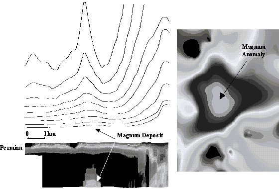
Figure 1: Left: GEOTEM profile with conductivity-depth section over the Magnum discovery, right: amplitude contour map from the PROTEM ground follow up survey.
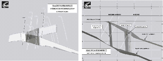
It appears that mineralisation is best developed within a gabbro sill that can be traced for approximately 6,000m to the south with a coincident highly anomalous gold copper geochemical response. The gold and copper mineralisation remains open in all directions.
North Atlantic Natural Resources follow up of a GEOTEM anomaly at Storliden, 8 km NE from the town of Malå in Sweden, led to a discovery of massive sulphide mineralisation with exceptionally high grades of zinc and copper. A recent resource estimate, based on fifty-seven drill holes, yielded 1.8 million tonnes averaging 10.0% zinc and 4.0% copper. Initial metallurgical, mine planning and environmental studies are currently in progress and an application for a mining permit has been submitted.
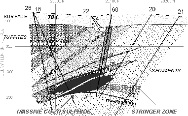
Storliden is a volcanic hosted massive sulphide (VHMS) zinc-copper deposit, located in the western Skellefteå district, in an area which has no prior history of mining, although the Skellefteå district is one of the most important Proterozoic VHMS mining regions in the world. Storliden consists of several sub-horizontal and partially overlapping lens shaped bodies of massive sulphide mineralisation hosted by Proterozoic volcano-sedimentary rocks (cf Figure 3). Ore minerals are sphalerite and chalcopyrite within a gangue that is predominantly pyrrhotite. The mineralised system has an overall strike length of some 400 meters and width of 100 meters. Individual mineralised zones vary in thickness from 0.5 to 28 meters with an average of 8 meters. Bedrock is covered by approximately 20 meters of glacial till. The richest part of the deposit does not sub-outcrop and lies approximately 130 meters below ground surface.
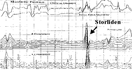
The GEOTEMTM survey was flown along survey lines oriented NE-SW and spaced 200 m apart. The survey revealed a number of features worthy of further investigations on the ground. One of these, subsequently named Storliden, is situated in an area of thick glacial overburden. This anomaly (marked with an arrow on Figure 4) displays a strong EM response in all 24 channels displayed and the other 96 (not displayed). The body causing the anomaly is interpreted to be 400 m long dipping to the southwest at a depth to top of 110 metres. It has no obvious cultural explanation and was considered likely to reflect either a relatively shallow body of massive sulphide mineralisation or a bedrock unit with a high content of graphite. A coincident positive magnetic response gave the anomaly added significance.
The Storliden anomaly was assigned a priority rating for ground follow up. This program was intended to confirm the airborne anomaly and to provide targets for an initial phase of scout diamond drilling. Horizontal loop electromagnetic (HL-EM) profiles verified the airborne pattern and indicated a conductor 400 m long, dipping sub-vertically, at a depth of some 35 metres. This feature was chosen as the first drilling target at Storliden. The first drillhole intersected a steeply dipping mineralised zone with a true width of some 20-25 metres containing predominantly pyrrhotite. The ground magnetic survey over the same grid as the HL-EM revealed an anomaly of 200 nT, with the same general shape as the airborne magnetic anomaly. This anomaly was subsequently found to bear a close relation to the main ore body.
Following initial recognition of what later became the main ore body, further geophysical surveys of various types were conducted at Storliden. A transient electromagnetic (TEM) survey with a large 700 by 300 metre loop showed a strong response over the main ore body. The interpretation of the TEM response reflects a sub-vertical, tabular conductor linked at depth to a sub-horizontal conductor with a shallow dip to the south. The sub-vertical body can be attributed to a pyrite-pyrrhotite zone of veins and stockworks lying above the sub-horizontal lenses of massive high-grade copper and zinc sulfide zone.
Although the initial HL-EM ground survey detected only the vertical part of the deposit, the TEM survey was capable of delineating the sub-horizontal, main part of the ore body. The shape of the GEOTEM anomaly on the discovery profile also clearly indicates a sub-horizontal body. Models of conductive plates show that a vertical body produces two peaks of almost equal height in the Z-component of the response with a single peak and slight undershoot in the X-component. Varying the dip of the modelled conductive plate shows that only a dip of 30 degrees or less produces the strong Z-peak on the down-dip side with a negative on the up-dip side, as well as a symmetric, single-peak response in X. Not only does this indicate the correct direction of the dip as SW, but it also provides a very shallow angle. Therefore, the GEOTEM anomaly can be assigned to the sub-horizontal, main orebody and not to the sub-vertical stringer zone.
Ellendale pipes 41, 42 and 43 are part of larger Ellendale lamproite field, located in the Kimberley region of Western Australia (Jenke, 1983, Atkinson, 1986). The region is relatively flat, with large areas of alluvial gravels and sands at the surface. This feature of the landscape obscures the pipes, rendering them blind. The overburden blanket is resistive and although it obscures the outcrop geology from surface investigations, it is not an obstacle to DIGHEMTM EM investigations. The residual magnetic intensity over the area surrounding the three lamproite pipes shows a broad background magnetic gradient, overprinted by high frequency laterite surficial noise. Of the three pipes, only Ellendale 42 shows a magnetic signature that would distinguish it from the surrounding lateritic signal, making magnetic surveys of limited value for locating targets such as pipes 41 and 43. DIGHEMTM EM data however, located and identified all three pipes as seen in the left frame of Figure 5.
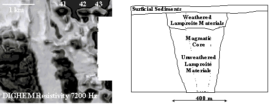
Figure 5: Left: DIGHEMTM resistivity image at 7200 Hz showing 3 lamproite pipes, right: geological cross-section through Ellendale 41.
Ellendale 41, the largest of a the three small pipes, is oval, about 400 x 300 m (9.3 ha), and is concealed beneath about 5 m of sand and clay overburden. The vent contains a small magmatic core of olivine-leucite lamproite intruding lapilli-tuff (cf. right frame of Figure 6)
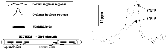 Figure 6 modelled DIGHEMTM response over a horizontal disk, right: the 400 Hz coplanar (single peak) and 900 Hz coaxial (double peak), in-phase response over the Ellendale 41 pipe.
The survey over the Ellendale 41, 42 and 43 pipes was carried out using the industry standard DIGHEMTM system, which is configured with both coplanar and coaxial coils for geometric analysis of conductor responses. Differing conductor geometries result in distinctly different responses from coaxial and coplanar coil pairs, due to the orientation of the EM field induced by each differently oriented coil pair. A modelled response over a horizontal conductive disk (left frame in Figure 6), indicates the kind of EM responses expected over the weathered surficial plug of a kimberlite or lamproite.
The two profiles in the right frame of Figure 6 show 900 Hz coaxial and 400 Hz coplanar in-phase responses over the Ellendale 41 pipe. The clear character of the EM responses over the pipe (double peak coaxial, single peak coplanar) makes this feature of the DIGHEMTM system a valuable discrimination tool in kimberlite and lamproite exploration.
We would like to thank David Jones and Miles Kennedy of Kimberley Resources for their permission to display the images from Ellendale. Ana Brana of North Atlantic Natural Resources (NAN) provided us with much of the geological and geophysical information about the exploration program that lead to the discovery and subsequent mine application, and Ted Posey kindly permitted publication of the data. We would like to thank Andy Viner at Gindalbie Gold and Mike Fowler at Croesus Mining for their support and permission to show the Anketell data over the Magnum deposit. Finally, we extend special thanks to Tom Whiting and Jonathan Lowe of BHP for flying the Anketell survey, describing the progression of the exploration program, and allowing publication of the results.
Atkinson, W.J., 1986, Diamond exploration philosophy, practice and promises: A review, in: Ross, J., Ed., Kimberlites and related rocks, Vol. 2: Proc. 4th Int. Kimberlite Conf., Geol. Soc. Austral., spec. publ. 14, 1075-1107.
Brana, A., 1999, The Storliden project a geophysical discovery. The Gold 99 Symposium, Trondheim, Norway May 1999.
Croesus Mining website: www.croesus.com.au
Gindalbie Gold website: www.gindalbie.com.au
Jenke, G., 1983, The role of geophysics in the discovery of the Ellendale and Fitzroy Kimberlites: 3rd Biennial Conf., Austral. Soc. Expl. Geophys., Abstracts, 66-72.
Macnae, J.C., 1976, Kimberlites and exploration geophysics, Geophysics 44, 1395-1416.
North Atlantic Natural Resources website: www.nanr.se
Posey, E.F., 1999a, Annual Report 1998, North Atlantic Natural Resources AB, Uppsala, Sweden.
Posey, E.F., 1999b, Discovery of the Storliden Cu-Zn VMS deposit, presented at PDAC Conference, Toronto, 1999.
South Atlantic Natural Resources website: www.scq.com