G Neil Phillips
CSIRO Exploration and Mining, Clayton, Victoria, 3168, Australia
Graham Carr
CSIRO Exploration and Mining, North Ryde, NSW, 2113, Australia
Key Words: Exploration, Hyperspectral, Core Logger, Geoinfomatics,Glass Earth
CSIRO embarked on a new strategy in 2001 under the leadership of Dr Geoff Garrett that involved strengthening external partnerships, growing its business, and developing networks in some emerging science areas. Initiating Flagship Projects of national scale and tackling long-term issues will create opportunities for collaboration between CSIRO, universities and other research providers and users.
CSIRO’s Division of Exploration and Mining has been very much part of these changes by growing its mining effort, repositioning itself in exploration, and being a partner in two new Cooperative Research Centres. Small teams have been established in seven billion-dollar-plus commodity areas to work more closely with industry.
In many Australian terrains the headframe casts it shadow over hundreds of square kilometres of featureless plains, where exploration is no less challenging than in the green fields environment. In both environments good geology matched with advanced technology is the key to success.
CSIRO is continuing to develop concepts and technologies for the mineral industry, and is now focussing more of it efforts in the near mine and brownfields exploration areas. Much of this exploration is being carried out under the banner of the Glass Earth project. Glass Earth is the long-term collaborative national project to give us the capabilities to make the top kilometre of the Australian continent transparent. This is a CSIRO initiative now gaining currency across the spectrum of research agencies both as a platform of collaborative integrated research and a way of creating both public and political interest in the exploration industry. Some of these initiatives are discussed below.
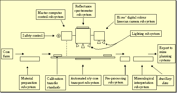
Near-mine exploration requires, inter alia, high quality, high-resolution data that can be integrated and interpreted in single, 3D visualisation platforms. An exciting new development in data collection is the hyperspectral core logger. This technology translates instrumentation and interpretation algorithms used for airborne surveys to the bench scale. It provides objective, on-site direct mineralogical and indirect geochemical data on drill core and drill cuttings in real time. It is currently being developed in collaboration with mineral exploration companies and geological surveys through AMIRA.
|

The hyperspectral core logger will complement existing down-hole spectrometric nuclear logging tools that CSIRO has developed in association with its commercial partner Scintrex/Auslog. Borehole logging and hand held instruments employing natural gamma, gamma-gamma and neutron-gamma techniques provide the capability for orebody delineation, lithological logging, selected mineralogy discrimination and selected grade estimation in a wide range of commodities including coal, iron ore, nickel, base metals, copper and some industrial minerals.
Geochemical Exploration
SIRO, partly in collaboration with CRC LEME, is developing innovative methods for the identification of both primary and secondary geological processes using multielement geochemical data from drill holes and systematic grid sampling arrays. The aim is to map the evolution of secondary geochemical processes, particularly in lateritised terranes, and primary metal zonation around mineralisation and to maximise the influence of sparse sampling, thus contributing to both exploration effectiveness and cost efficiencies particularly beneath covered sequences.
Other programs are assessing the application of partial digestion technologies using isotopic discriminators and groundwater sampling, analysis and interpretation to provide vectors to ore accumulations.
Geoinfomatics, the science of turning geo-data into information, is a burgeoning field that has particular application in the data-rich environment near to current mining operations. Successful exploration relies on making the best use of available historical data as well as being able to integrate large complex datasets. CSIRO is currently developing skills and advanced computational technologies for:
· Efficient construction of geometric 3D/4D geological models at all scales using all available data (e.g. mapped geology, potential field, multi-spectral, seismic),
· Computer simulation of the geological processes which contribute to the formation of all types of ore deposits, and
· Efficient visualisation of the results.
The software aims to combine geoscientific databases, modelling packages and visualisation into one coherent web-based computational environment. This allows the user a seamless access to data, models and a combination of computational platforms. The objective is to bring the full range of numerical modelling power to bear on geologically-based targeting decisions. This has the capacity to dramatically improve the quality of targets tested, and reduce the cost of discovery.
The highest cost component of any exploration program is drilling. With support from AMIRA, CSIRO is using advanced diamond composite materials to develop longer life, more efficient diamond drill bits.
Much of the apparent focus on exploration around the headframe reflects the dramatic decrease in the greenfields exploration that is required to find new mineral provinces and underpin the industry in this country. Australia is well positioned when exploration spending does increase, but it is important that we have the technologies and ideas appropriate for that time.