Neil Hughes and David McInnes
Pasminco Exploration, Level 7, Royal Domain Centre, 380 St Kilda Road, Melbourne, VIC 3004
Keywords : gold, copper, Curnamona Province , Willyama Supergroup, gravity, induced polarisation, resistivity, aero-magnetics
The Benagerie tenement EL2152 has been held in joint venture between Pasminco Exploration (70%) and Lynch Mining (30%) since August 1991, with Werrie Gold Limited exercising an option over Lynch Minings share since 1996. The tenement is located approximately 100km north west of the city of Broken Hill within the Olary Block of the Curnamona Craton. Tertiary sands and clays blanket the tenement with only one small outcrop of the Willyama Supergroup known.
Exploration for primary Pb-Zn and Cu-Au deposits in this area has traditionally relied on the use of aero-magnetics and regional gravity with follow-up air-core drilling. The discovery of secondary gold mineralisation at the Portia prospect in 1995 led to the trialing of detailed gravity, induced polarisation and electro-magnetics to aid in the discovery of a primary source. Expansion of detailed gravity surveys over the Benagerie Ridge Magnetic Complex (BRMC) led to the delineation of a number of Cu-Au prospects. Application of electrical techniques have mapped the prospective horizons at depth, including the host to primary Cu-Au mineralisation at the North Portia prospect. Down-hole physical property logging has aided in characterising the cover sequence and the host rocks to mineralisation.
Electrical and potential geophysical methods have been significant exploration tools in the discovery and delineation of primary and secondary Cu-Au on the Benagerie Ridge. However the variable thickness and high conductivity of the Tertiary cover sequence have provided significant challenges during the application of these geophysical techniques.
EL2512 Benagerie was taken up initially to explore for Pb-Zn of the Mt Isa and Broken Hill type targeting the Bimba and lower pelite position using a structural and stratigraphic framework based on regional and detailed aero-magnetics. Target areas were tested with a single line of air-core drilling using 50m or 100m sample intervals. The tenement lies approximately 100 km north west of the City of Broken Hill within the Olary Block of the Curnamona Craton. Tertiary sands and clays blanket the tenement with only one small outcrop of the Willyama Supergroup known (Figure 1).
The tenement was flown in 1991 with detailed aero-magnetics which afforded a detailed magneto-stratigraphic and structural frame work to be formed based on applying a broad analogy to the Broken Hill block stratigraphy. In late 1992 the tenement was flown with airborne EM using the lowest base frequency available at the time, 37.5 Hz. A number of anomalies were defined and tested with air-core drilling. A limited amount of widely spaced ground EM and IP was also undertaken within the magnetically bland pelite suite adjacent to the Bimba Horizon to test aero-magnetically defined structures and anomalies.
The discovery of the Portia secondary Au mineralisation during 1995/1996 led to the trialing of detailed gravity, induced polarisation (IP) and transient electromagnetic (EM) surveys to aid in characterising the mineralising setting and to direct exploration for primary Cu-Au mineralisation under the thick Tertiary cover. The success of the detailed gravity over Portia led to a progressive expansion of coverage over the BRMC and in combination with aero-magnetics has proved to be a powerful tool for mapping alteration and targeting both secondary and primary mineralisation systems. Use of IP has also been effective in detecting and mapping sulphide rich horizons below the thick, conductive, Tertiary cover
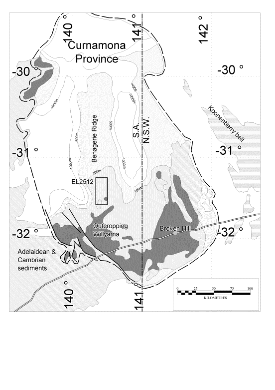
The regional geology of the Benagerie Tenement area incorporates a Paleoproterozoic basement of Willyama Supergroup which is overlain in part by Neoproterozoic Cambian sediments (Bierlein et al, 1995). Tertiary sands and clays blanket the tenement to a thickness which varies from 10 to 100m, with only a single outcrop of Willyama known. Historically only the Willyama Supergroup has been considered prospective for economic primary Cu-Au and Pb-Zn-Ag.(Figure 1).
The stratigraphy of the Willyama Supergroup in the area includes a basal, highly migmatitic Composite Gneiss Suite (CGS) which is overlain by an extensive Quartzo-feldspathic Suite (QFS) of predominantly albite-quartz composition. The QFS grades upwards into a Calc-silicate Suite (CS) which is commonly mineralised (Cu-Zn-Co-Mo-Au-As) with low grade deposits; the suite also commonly contains stratabound breccias which often display haematite-rich alteration. Overlying the CS is the thin, relatively continuous, but highly heterogeneous Bimba Horizon (BH), which is sulphide rich and often gossanous when exposed. The BH is overlain by a Pelitic Suite (PS), which is distinctly graphitic towards its base. Metamorphic grade at Benagerie is generally of greenschist facies (Bierlein et al, 1995, Hudson et. al., 1999).
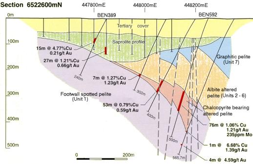
Diamond drilling by Pasminco at the margins of the BRMC has enabled the construction of a well defined sequence within which known mineralisation is hosted. This includes (but may not include all units) a scapolite-bearing albitic basal unit which is magnetic towards its top (Unit 1), a banded albitite which is host to the high grade mineralisation(Unit 2), an albitic unit (Unit 3), a banded carbonate-scapolite albite (Unit 4), a pyritic albitite (Unit 5), a biotite carbonate ± actinolite schist (Unit 6), and a carbonaceous argillite which is commonly pyritic (Unit 7) (Hudson, 1999). Significant brittle faulting has dissected and displaced mineralisation (Hudson et. al., 1999). Figure 2 shows a summary geological cross section through the North Portia prospect.
Dominant mineralisation styles observed to date include coarse free gold in intensely weathered albitised graphitic meta pelite, fracture and lamination controlled chalcopyrite veins, both as replacement and infill; native gold present as discrete primary grains, inclusions in chalcopyrite and as nuggets; and molybdenite as shear and vein infill. Other anomalous metals include Pb, Zn, Co, U and Ag (Hudson et. al., 1999).
An inferred resource for the base of Tertiary eluvial mineralisation at the Portia prospect has been estimated at 270,000 t averaging 7 g/t Au (Skidmore and Fielding, 1999).
A detailed aero-magnetics survey was flown over the tenement in 1991 on east west lines at 150m separation and flight height of 40m. This survey afforded a detailed interpretation based on known geology and drilling.
The BRMC is one of a number of distinctive magnetic features in the northern Olary Block. It is characterised as displaying a high degree of internal variability and has traditionally been interpreted as representing a structurally controlled basement high bringing magnetic sediments of the QFS closer to surface (Figure 3). This view dominated the early stages of exploration. It has a dominant north south strike with north east and north west structural trends common.
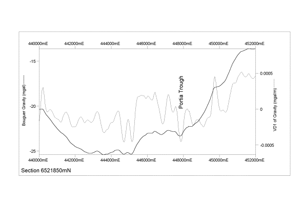
Figure 4 shows the reduced to the pole residual total magnetic intensity and its first vertical derivative at northing 6521850mN. The Portia prospect is located on the eastern edge of the magnetic complex. The data indicates that at Portia magnetic units dip moderately to steeply east and there is evidence of unit offsets; all of which is supported by drilling.
Within the BRMC the average depth to (strongly) magnetic features is 120m which reflects the average depth of cover and weathering
Remodelling of the magnetic data and reinterpretation of the composition and origin of the magnetic complex from diamond drilling has developed a new model for the BRMC incorporating stratigraphy, alteration and mineralisation.
An airborne EM survey was flown over the tenement in late 1992 using the QUESTEM system at a base frequency of 37.5Hz, the lowest available at the time, and measuring the in-line component of the decay of the secondary magnetic field over 15 time windows. Lines were flown in an east west direction at a spacing of 500m. The height of the plane was 120m and the receiver coil 55m.
No obvious discrete, late time conductors were detected during the surveys. However the data has been used to map variations in the cover thickness and conductivity (through the use of conductivity depth transforms) as well as highlighting structural trends. Areas of thin or resistive cover are well mapped by using the differences between early time windows. The conductance of the cover sequence appears to vary from a few Siemens to greater than 50 Siemens.
Application of principal component analysis allows one to display much of the inherent data in the 15 time channels in just 3 or 4 channels. Variation between the principal component can be viewed by combining them into an ternary image. This type of presentation has been useful in mapping variation in the cover units as well as geological trends under the cover.
Gold was discovered within weathered basement at what is now the Portia prospect during an air-core drilling programme in 1995. Detailed trial gravity lines over the prospect showed that mineralisation coincided with the axis of a significant local gravity low. (Figure 5) These lows are interpreted to represent zones of deep weathering resulting from the breakdown of feldspathic alteration in the presence of acidic ground water sourced from sulphide rich bedrock. (Newbery & Skidmore, 1998, Hudson et al, 1999).
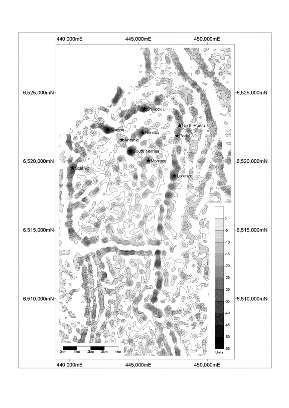
Following the success of trial gravity surveys at Portia they were expanded to cover much of the BRMC with the discovery of a number of new prospects, including North Portia. These are well seen in the 2nd vertical derivative map in Figure 6 where only negative anomalies are highlighted. The more negative the contour value the less dense, or deeper is the cover and weathering. Numerous structural trends are also evident in the figure; particularly those with a north west trend. Data sample density varies from 25m x 25m to 100m x 200m, and is complemented by 1km x 1km data collected on behalf of the South Australian Mines Department in 1996 which covers much of the Benagerie and surrounding tenements.
The BRMC is coincident with a distinct north south oriented 10km x 20km gravity low that is interpreted to be due to an underlying alkaline intrusive. To the south of the tenement a granite has been intersected at shallow depth coincident with the most pronounced gravity low of the trough.
The collection of high density gravity data, together with a knowledge of the density characteristics of the cover, weathered and fresh basement, has allowed the construction of drill-constrained layered earth models to guide ongoing drilling.(Fullagar, et al, 1999).
Accurate location information collected for the gravity surveys allows a detailed elevation model to be generated. Once a regional background has been removed the resultant image maps the location and orientation of the sand dunes as well as numerous structural trends, which tend to be coincident to those mapped with detailed gravity and aero-magnetics.
Physical property logging has been undertaken in a number of air-core and diamond drill-holes to help characterise both the cover and host sequence.
Figures 7a. And 7b. Show some of the physical property logs collected for air-core hole 389 and diamond drill hole 592 from the North Portia prospect (See figure 2) . AC389 intersected 27m @1.21%Cu and 0.66 g/t Au within a goethite kaolinite-quartz saprolite, and diamond hole 592 intersected 76m @ 1.06% Cu, 1.21 g/t Au, 235ppm Mo within albite altered pelite.
The cover sequence includes shallow Quaternary sands and soils and a number of Tertiary sand and clay layers, including an upper light sandy clay, a dark gritty clay, an olive grey clay and a light grey clay (which is not all ways present). High grade eluvial gold is found at this base of Tertiary immediately above basement saprolite.
The cover sequence is characterised by resistivities of the order of 2.5 ohm-m, higher for sand
and sandy clay units, densities of 1.6 for sand and sandy clays, 2.1 for compact clays and saprolite. The cover sequence tends to be non magnetic, generally less than 20 x 10-5 SI.
Physical property logs for diamond drill hole 592 clearly map the location of the footwall altered pelite at a depth of 377m characterised by a significant increase in magnetic susceptibility activity, an increase in resistivity (to 1000’s of ohm-m) and absence of any significant Au or Cu mineralisation. Effects of intense faulting and deeper weathering to a depth of 213m are characterised by decreased resistivities (~10 ohm-m). There is a clear correspondence between increased conductivity and intensity of mineralisation and copper grade. The spiky appearance of the apparent resistivity log is a result of logging in a perforated PVC lined drill-hole.
A comparison of detailed dipole-dipole IP using 50m dipoles and 50m moving loop EM over the Portia prospect suggested that the IP method was better able to map the interface between the cover and weathered layer, and fresh basement. An added benefit of the method is the recognition that primary Cu-Au mineralisation may be associated with disseminated pyrite and be detectable as a chargeability response but not recognisable in EM surveys. The cover sequence appears to be non-chargeable.
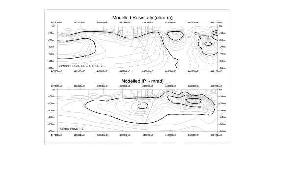
Figure 8a. shows the decoupled phase and apparent resistivity pseudo-sections over part of line 6522600mN, North Portia. Data was collected using phase domain equipment, a base frequency of 0.125Hz and a 150m dipole spacing. The most prominent features are the extremely high IP values and low apparent resistivity values associated apparently with a graphitic schist to the east .
Upon transforming the data to resistivity and IP depth sections (Figure 8b.) using Zonge’s two dimensional finite element IP inversion software (McInnes, 1998) it is evident that there are two chargeable sources. One related to the graphitic schist to the east of the North Portia prospect, at a relatively shallow depth, and a second, lower amplitude anomaly, centred at 448100mE at a depth of approximately 250m, which corresponds to primary Cu-Au mineralisation in a pyritic albite altered pelite. The graphitic schist corresponds with a well defined resistivity low, however there is no resistivity feature that corresponds to the IP anomaly. The North Portia weathering trough is also well mapped. Drill-hole resistivity and conductivity logging suggests that the intersected mineralisation, although locally conductive, is not sufficiently conductive in bulk to be detectable from surface IP or EM surveys in this environment.
The use of detailed gravity has been highly effective in mapping deep weathering troughs resulting from the breakdown of feldspathic alteration in the presence of acidic ground water sourced from sulphide rich bedrock.
IP surveying has been successful in mapping pyritic rich albite altered pelites below the thick, conductive, Tertiary cover. The combination of gravity and aero-magnetics has proved to be a powerful tool for mapping alteration and targeting both secondary and primary mineralisation systems.
Exploration work continues at Benagerie to test the many targets defined by gravity and magnetics as well as refining the exploration model.
The authors would like to acknowledge the many staff from Pasminco and Werie Gold Ltd, and contractors and consultants who have worked on this project and thank Pasminco Ltd and Werie Gold Ltd for permission to publish this paper
Bierlein, F.P., Ashley, P.M., Plimer, I.R., 1995, Sulphide mineralisation in the Olary Block, South Australia. Mineral Deposita. 30, 424-438.
Hudson, M., 1999, Benagerie EL2512, Review of Exploration 1991-1999. Unpublished Pasminco Report.
Newbery, S.P. and Skidmore, C.P., 1998, Exploration for FE-oxide copper-gold ore systems within the Benagerie Ridge Magnetic Complex. AGSO Record : 1998/25
MacInnes. S. 1998. Imaging resistivity and Induced Polarisation with Inversion: ASEG Workshop. 13th International Geophysical Conference and Exhibition.
Skidmore, C.P. and Fielding, D.C., 1999, Resource Potential Portia Prospect. Unpublished Pasminco Report.
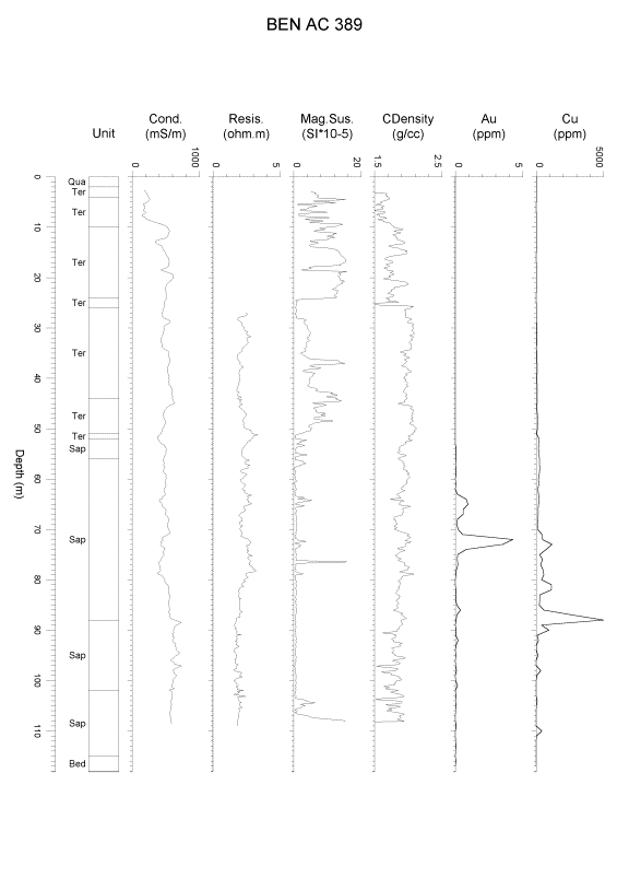
Figure 1. Generalised geology of Curnamona Province showing location of EL2512 and depth contours to Willyama Supergroup
Figure 2. Cross section through North Portia Prospect – 6522600mN
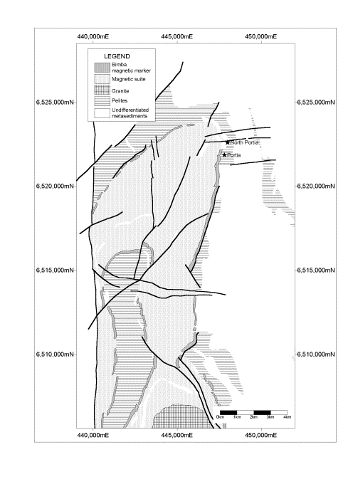
Figure 3. Summary aero-magnetic interpretation over the BRMC.
Figure 4. East -west profile of Reduced to the Pole Total Magnetic Intensity (residual) and it first vertical derivative at northing 6521850mN with the location of the Portia Prospect shown.
Figure 5. East -west profile of Bouguer gravity and it first vertical derivative at northing 6521850mN with the location of the Portia Prospect shown.
Figure 6. Filled contours of the 2nd vertical derivative (or Laplacian) of Bouguer gravity. Only negatives have been displayed to highlight areas of reduced density – increased depths of weathering and cover.
Figure 7a. Down-hole apparent resistivity, conductivity, magnetic susceptibility, compensated density logs, summary geology, and Cu and Au grades for air-core drill hole BEN389, section 6522600mN.
Figure 7b. Down-hole apparent resistivity, conductivity, magnetic susceptibility logs, summary geology, and Cu and Au grades for diamond drill hole BEN592, section 6522600mN.
Figure 8a. Part of a dipole-dipole IP and Resistivity traverse at 6522600mN, North Portia. Dipole length is 150m.
Figure 8b. Part of the modelled IP and Resistivity at 6522600mN, North Portia, including air-core and diamond drill-holes.
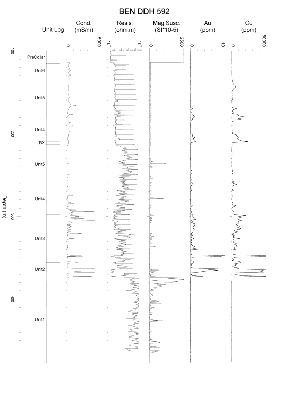
Figure 7a. Down-hole apparent resistivity, conductivity, magnetic susceptibility, compensated density logs, summary geology, and Cu and Au grades for air-core drill hole BEN389, section 6522600mN.