John Holliday, Colin McMillan and Ian Tedder,
Newcrest Mining Limited, Exploration Department, 1460 Cadia Road, Cadia via Orange, NSW, 2800.
Key Words: Cadia, gold, copper, porphyry, drilling, magnetics, induced polarisation
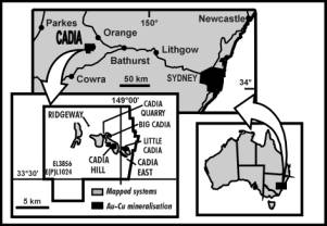
The Cadia Ridgeway deposit is one of a group of porphyry-style deposits discovered since 1992 by Newcrest geologists (Wood and Holliday, 1995; Holliday et al, 1998), at Cadia 20 kms south of Orange in the central tablelands of NSW. The Ridgeway deposit lies 500m below the surface, 3 kms north-west of the Cadia Hill open cut mine, and was discovered in November 1996. It is notably rich in Au with an inferred and indicated resource of 44 Mt at 2.6 g/t Au and 0.82% Cu, and is currently under development as an underground mining operation.
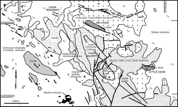
The Cadia deposits are part of a Late Ordovician Early Silurian porphyry alteration-mineralisation system that extends over an area of at least 6 X 2 km within the Ordovician Molong Volcanic Belt of the Palaeozoic Lachlan Fold Belt (Newcrest Mining Staff, 1997). The Molong Volcanic Belt comprises a suite of intermediate to basic volcanics, volcaniclastics, comagmatic intrusions, and limestones. The suite is probably part of a subduction-related island arc disrupted by later tectonism (Glen et al, 1997). In the Cadia area the volcanics and intrusions are shoshonitic (Blevin, 1998).
Mineralisation styles at Cadia include sheeted quartz vein, stockwork quartz vein, disseminated and skarn, all of which are genetically related to a relatively small (3 X 1.5 km in outcrop) composite intrusion of predominantly monzonitic composition, with a monzodioritic to dioritic rind (Cadia Hill Monzonite). The Cadia Hill Monzonite intruded Forest Reefs Volcanics (volcaniclastics, lavas, subvolcanic intrusions, and minor limestone) and Weemalla Formation (siltstone, mudstone, minor volcaniclastics). Emplacement of the Cadia Hill Monzonite was probably facilitated and localised by the development of a major north-west (NW) to south-east (SE) trending dilational structural zone, which is well evident in magnetic data. The Cadia deposits, including Ridgeway, are aligned in this zone.
The Ridgeway deposit is an upright bulbous body of stockwork quartz veining zoned about a small (50-100 m diameter) plug of Cadia Hill Monzonite porphyry (Newcrest Mining Staff, 1998). The plug has intruded relatively flat-lying, conformable Forest Reefs Volcanics and Weemalla Formation to the west of the main Cadia intrusion. Spatially related pre-mineral intrusions include monzodiorite and pyroxene porphyry dykes. The most intense stockwork veining and alteration, and the highest Au and Cu grades occur immediately adjacent to the monzonite porphyry. The best part of the orebody occurs above the porphyry and the weaker parts along the sides. The intensity of veining and alteration declines both outwards and inwards from the monzonite porphyry margin. This results in a small low-grade central portion in the monzonite porphyry. Ore minerals are native gold, chalcopyrite and bornite, mostly occurring within veins, but also disseminated. Magnetite is a major accessory mineral in veins. Hydrothermal alteration associated with the strongest mineralisation is potassic: orthoclase,
albite, actinolite, magnetite, biotite. This is overprinted by later propylitic assemblages: epidote, chlorite, Fe-carbonate, calcite, hematite dusting. Structures cutting the mineralisation had significant
pre-mineral movement with the conformable Forest Reefs Volcanics-Weemalla Formation contact off-set by ±130m on a NW-SE alignment. However there was little syn or post-mineral movement, since the mineralisation has no major offsets. The northern edge of the deposit is cut by the North Fault, a vertical, NW-SE aligned structure along which a pre-mineral pyroxene porphyry dyke was intruded. Ridgeway is a small porphyry mineralisation system subsidiary to a larger system, and is thus comparable to the Goonumbla porphyries (Heithersay et al, 1990), also in the Lachlan Fold Belt.
Most significantly from an exploration viewpoint Ridgeway lies 500m below the surface, at a site covered by Miocene-aged basalt flows, 20-80m thick. Beneath these flows there is a palaeo-weathered surface on the Forest Reefs Volcanics (±20m of oxidation and another ±30m of leaching). Strong alteration and anomalous metal values related to the deposit do not extend upwards for sufficient distance to be detectable at or for a considerable distance below the palaeo-surface.
Modern era exploration at the site was prompted by its proximity to the mineralised Cadia district, and particularly by the recognition of magnetic features, which can easily be interpreted as westward extensions or repetitions of the magnetic anomaly over the magnetic skarn at Big Cadia. In 1985 Homestake Australia drilled two RC percussion holes to downhole depths of 95m to test magnetic targets, with very poor results. In 1991 Newcrest drilled seven further RC percussion holes to downhole depths of 42-90m to more comprehensively test the magnetic targets, also with very poor results. All these holes intersected magnetic volcanic rocks, which were considered to explain the magnetic features. In part they did, but none of them went nearly deep enough to encounter any mineralisation.
In late 1992 the Cadia Hill deposit was discovered and at the same time an extensive halo of low-grade mineralisation was delineated to the NW of the deposit at Cadia Quarry. These results confirmed the NW to SE alignment of mineralisation at Cadia so step-out drilling was continued in both directions. Most importantly this drilling was conducted in a manner suited to the discovery and delineation of large mineral systems, with core holes typically 300-600m in length on 200m step-outs. Almost immediately the Cadia East deposit was discovered east of Cadia Hill. To the NW the Cadia Quarry mineralisation was found to extend for about 1 km, beyond which there was barren intrusive and volcanics both in holes and on surface. A further 1km NW the basalt cover begins.
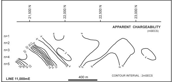
In an attempt to focus the exploration drilling NW of Cadia Quarry a regional reconnaissance IP survey was conducted in spring 1994. This survey used a 200m dipole-dipole configuration after orientation surveys had shown that the method could detect both the outcropping, but very low sulphide Cadia Hill mineralisation, and the covered (60-200m), high sulphide Cadia East mineralisation. The 200m dipole spacing was found to be necessary for both the depth penetration and lateral coverage needed over large mineralised systems. The aim of the new survey was to detect large, deep bodies of disseminated mineralisation, which it was expected would only show up at the bottom of the chargeability pseudosections. The survey obtained only one anomaly with these expected characteristics and which could not be explained by lithological contrasts. This was at, and east of, the Ridgeway site on three 200m spaced traverses. The anomaly was particularly attractive because it lay on the NW-SE alignment of mineralisation. Recent modelling work has suggested that the IP did not detect the Ridgeway high-grade ore because it is too deep. It is currently thought that it detected a disseminated pyrite halo above the ore. Whatever it actually detected the IP survey was important because it encouraged drilling sooner, in what turned out to be the right place.
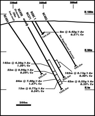
In February and March, 1995 two fences of RC percussion holes to 200m downhole depth were drilled to test the IP chargeability and mineralisation corridor target. The first of a total of nine holes (RGRC1) obtained the most significant result: 8m at 0.42g/t Au and 0.53% Cu from 182m, but there were 27 other narrow intercepts of +0.10g/t Au in the holes. The RGRC1 intersection is now known to be due to an extreme outer halo leakage vein above the Ridgeway deposit. The RC holes intersected magnetic diorite or volcanics with >0.5% disseminated pyrite which was thought at the time to explain the IP effect. One of the western holes intersected anomalous Zn. It was possible to interpret a coherent alteration-metal zonation pattern from the holes, which implied that there might be a mineralised body at greater depth. This was regarded as a bit of a long shot at the time, but a deep hole behind RGRC1 was planned.
At the same time as the RC percussion drilling was in progress a fence of wide-spaced core holes (NC’s 368-370) was drilled to 500+m downhole depth, across the NW-SE mineralisation trend at a position one kilometre to the east of Ridgeway. It was considered at the time that none of these holes had obtained significant intersections of mineralisation, but the presence of encouraging alteration, particularly hematite dusting of feldspars was noted. In June 1995, as a continuation of this program, core hole NC371 was drilled beneath RGRC1 to a downhole depth of 513.6m. There were no obviously ore grade intersections so logging and assaying were delayed while priority was given to work at Cadia East and around Cadia Hill where feasibility study deadlines had to be met.
The NC371 assays were received in November 1995 and were reviewed in January 1996, along with the results of NC368 to NC370, as a prelude to further drilling in the area. They showed a zone of increasingly anomalous copper mineralisation (118m at 0.10%) from 396m to the end of the hole similar to the Cu signature observed adjacent to the Cadia Hill orebody, plus several narrow +1g/t gold intercepts including 1m at 5.68g/t Au from 359m and 2m at 10.6g/t from 410m. Narrow higher-grade Au intersections in NC’s 369 and 370 (such as 1m at 7.30g/t, 1m at 6.52g/t, and 2m at 6.98g/t) were also recognised as being significant. The narrow higher-grades were given a greater significance than they had previously because it was being increasingly recognised at that time that a higher grade ore discovery at Cadia could be vital for the Cadia Project’s economic viability. Based on the review of the drilling it was decided that NC371 should be deepened.
NC371 was deepened to 858.4m in February 1996. The deepened hole intersected chalcopyrite-bearing, sheeted vein style mineralisation from 610-711m. This mineralisation compared very well visually with similar style mineralisation at Cadia Hill and was considered immediately to probably be a new discovery. However assays showed that the vein zone carried very little gold: 610-712m at 0.13g/t Au and 0.40% Cu. The vein zone was terminated by a fault, below which several narrow higher-grade intersections were made: 1m at 2.44g/t Au from 726m, 3m at 3074ppm Cu from 733m, and 3m at 4.49g/t Au from 809m. The results were considered encouraging and it was decided to drill more deep core holes around NC371 along the NW-SE mineralisation trend. It is now known that NC371 had penetrated the halo to the high-grade Ridgeway deposit.
Holes were immediately drilled 350m south (NC484), and 175m north (NC485) of NC371 but the vein zone was not intersected. In May 1996 NC488 was drilled 275m east of NC371 and intersected broad Cu anomalism. It was a logical decision to drill across the mineralised trend, and then back towards other known mineralisation before drilling to the west, which is where the deposit proved to be. With the benefit of hindsight we also know that the step-out spacings for these holes was too large; in fact NC484 was deepened after the discovery to intersect the deposit.
It was decided after drilling NC488 to review the results before conducting more drilling around NC371, but it was already recognised that the best potential lay to the west. By this time wet mid-winter ground conditions meant that drilling had to be postponed until the spring anyway.
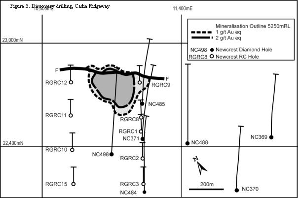
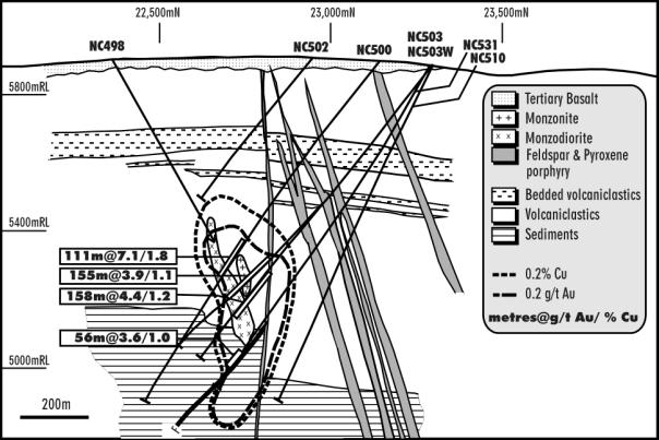
The precise siting of the discovery hole (NC498), 175m west of NC371, was made using a structural interpretation of the results from existing holes, supported by the results of the interpretation of a heli-mag survey flown in autumn 1996.
The structural interpretation was that the fault cutting off the vein zone in NC371 would be much deeper to the west, thereby allowing space for a much thicker vein zone if the zone extended westwards along the strike direction determined from measurements on NC371 core. It was predicted that the vein zone would be intersected at 550m downhole, and this proved to be very accurate.
The magnetic interpretation took account of a better understanding of the significance of magnetite alteration effects on the magnetic anomaly patterns. The magnetic features at Ridgeway were re-interpreted as being largely caused by alteration magnetite rather than primary magnetite and it was recognised that NC371 had drilled into an east-west cross-cutting magnetic low, which might be related to the mineralisation. The site selected by using the structural interpretation was in a suitable position to test this low.
By November 1996 the Ridgeway site was dry enough to allow access so hole NC498 was commenced. It intersected two zones of very high-grade, porphyry stockwork mineralisation — 145m from 598m at 4.30g/t Au and 1.20% Cu; and 84m from 821m at 7.40g/t Au and 1.27% Cu and the deposit was discovered.
The early post-discovery drilling included a scissors hole and 200m step-out holes to the west. At first it was thought that the deposit could be of the same scale (plus one hundred million tonnes) as Cadia Hill and Cadia East. However, it was quickly realised that Ridgeway was smaller, but of far higher grade than the other Cadia deposits. The deposit was drilled on 50 m sections from surface to inferred resource status by October, 1997, and to indicated and inferred resource status by July, 1998. The geological interpretation of the deposit changed as more data came available, with the description above being for the July, 1998 resource estimate. By June, 1999 a decline allowed access to the ore.
Ridgeway was discovered not just beneath 20-80m of Miocene cover, but also some 450m into the Ordovician host-rock sequence. It would not have been readily detectable on the Ordovician surface by any mapping or geochemical technique in the absence of the Miocene cover. It is also very uncertain whether any geophysical technique would have detected the deposit in the absence of the Miocene cover. It is debatable whether the 1994 IP survey really detected the deposit and further investigation into this is warranted. The deposit is not a conductor and was not detected by post-discovery downhole EM, even in a hole through the ore. The magnetic response at surface from the magnetite in the deposit veins is lost in the noise caused by stronger, nearer surface magnetic sources, which include the primary and alteration magnetite in the host volcanics and the monzodiorite. In fact, the deposit occurs in a relative magnetic low because of this juxtaposition of magnetic sources. There is no reason to suspect that gravity methods would detect the deposit since the density contrasts of the host lithologies are very small.
Drilling was the main discovery technique for Ridgeway. This may seem a statement of the obvious, since drilling is involved in nearly all discoveries. However, the deep drillholes leading up to the discovery, were specifically drilled in a partly stratigraphic sense to search for the geochemical and alteration vectors to a deposit. Hussey and Bernard (1998) describe a similar use of drillhole information leading to the discovery of the Porphyry Mountain Cu-Mo deposit in Canada.
As exploration of any terrain matures it becomes increasingly important to explore the third dimension. In exploring at the depths at which Ridgeway was found, drilling is clearly the best, and mostly the only option available. To improve the value of deep drillholes there is a pressing need for more developments in downhole geophysics techniques other than EM, for the detection of off-hole, non-conducting, but possibly polarisable and/or magnetic and/or dense bodies.
The most significant factors leading to the discovery of Ridgeway include, firstly the use of exploration techniques appropriate to the scale/style of the target being sought. The drilling and geophysics used were able to effectively search for and delineate the metal and alteration zonation patterns of the large Cadia mineralised system in all dimensions, particularly at depth.
Secondly, the recognition of the significance of the Cadia mineralisation system encouraged persistence. There was so much smoke there just had to be more deposits in the vicinity.
Thirdly, the ongoing enthusiasm and financial support for the exploration process from the Board level down, was vital. It was recognised that Newcrest needed Cadia to become bigger and better since it was the key to the immediate future of the Company.
Blevin, P., 1998, A re-evaluation of mineralised Ordovician intrusives in the Lachlan Fold Belt: implications for tectonic and metallogenic models. Geological Society of Australia Abstracts No 49, p43.
Glen, R.A., Walshe, J.L., Barron, L.M. & Watkins, J.J., 1997, New model for copper-gold deposits in Ordovician volcanics. Minfo No 56, NSW Department of Mineral Resources, Sydney.
Heithersay, P.S., ONeill, W.J., van der Helder, P., Moore, C.R. & Harbon, P.G., 1990, Goonumbla porphyry copper district Endeavour 26 North, Endeavour 22 and Endeavour 27 copper-gold deposits, in Geology of the Mineral Deposits of Australia and Papua New Guinea (Ed. F.E. Hughes) p1385 (AusIMM, Melbourne).
Holliday, J.R., Wood, D.G., McMillan C.C., Tedder, I.J., 1998, Discovery of the Cadia Au-Cu deposits, Lachlan Fold Belt, Australia. Pathways `98 Extended Abstracts Volume p74, British Columbia & Yukon Chamber of Mines, and Society of Economic Geologists.
Hussey, J. and Bernard, P., Exploration of the Porphyry Mountain Cu-Mo deposit. Mining Engineering, August, 1998.
Newcrest Mining Staff, 1997, Cadia gold-copper deposit, in Geology of Australian and Papua New Guinea Mineral Deposits (Eds. D.A. Berkman & D.H. Mackenzie) p641. (AusIMM, Melbourne).
Newcrest Mining Staff, 1998, Cadia gold-copper deposits: geological update. Geological Society of Australia Abstracts No 49, p334.
Newcrest Mining Limited, Various internal memoranda and monthly reports written between 1994 and 1999.
Wood, D.G. & Holliday, J.R., 1995, Discovery of the Cadia gold-copper deposit in New South Wales by refocussing the results of previous work. New Generation Gold Mines: Case Histories of Discovery, Australian Mineral Foundation, Adelaide.
See also, from “SEG News & Views”:
Dan Wood – Mineral Resource Discovery Science, Art & Business
SMEDG COMPETITION NUMBER 4 – CLUE #2
Hamish, Dougal and Bruce Dolf, Highland bachelors living in their remote Scottish keep, decided it was time to marry. The nearest women were miles away and some sort of event was required to attract the lasses and give the lads a chance to check the girls’ best qualities – in the time-honoured, old-fashioned and traditional way. Thus, the Clan Dolf Ball was arranged, just so you’d have an anagram to unravel. Now, a Cryptic Clue within a Clue – interestingly, Clue #1 lies within the Governor’s twisted strap. The Gov’s a good bloke, we’re on first name terms. On unravelling and rebuilding the anagram, remember you may have to visit more than one page to find Clue #3. If you stumble across a clue inadvertantly out of turn you may need to keep searching. Some, but not all, clues are useful later.